You are here: Home > Network List > N4 - Central and EAstern US Network Stations List
> Station L40A Anamosa, IA, USA > Earthquake Result Viewer
L40A Anamosa, IA, USA - Earthquake Result Viewer
| Earthquake location: |
Kuril Islands |
| Earthquake latitude/longitude: |
48.5/154.8 |
| Earthquake time(UTC): |
2018/08/10 (222) 18:12:05 GMT |
| Earthquake Depth: |
16 km |
| Earthquake Magnitude: |
5.9 Mww |
| Earthquake Catalog/Contributor: |
NEIC PDE/us |
|
| Network: |
N4 Central and EAstern US Network |
| Station: |
L40A Anamosa, IA, USA |
| Lat/Lon: |
42.06 N/91.22 W |
| Elevation: |
242 m |
|
| Distance: |
72.7 deg |
| Az: |
45.421 deg |
| Baz: |
320.462 deg |
| Ray Param: |
0.053445987 |
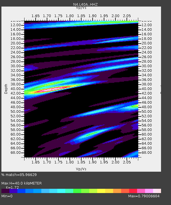
| Estimated Moho Depth: |
40.0 km |
| Estimated Crust Vp/Vs: |
1.72 |
| Assumed Crust Vp: |
6.53 km/s |
| Estimated Crust Vs: |
3.797 km/s |
| Estimated Crust Poisson's Ratio: |
0.24 |
|
| Radial Match: |
85.96629 % |
| Radial Bump: |
400 |
| Transverse Match: |
63.380478 % |
| Transverse Bump: |
400 |
| SOD ConfigId: |
13570011 |
| Insert Time: |
2019-04-30 18:35:58.428 +0000 |
| GWidth: |
2.5 |
| Max Bumps: |
400 |
| Tol: |
0.001 |
|

Signal To Noise
| Channel | StoN | STA | LTA |
| N4:L40A: :HHZ:20180810T18:23:01.260007Z | 10.752615 | 1.0484727E-6 | 9.750861E-8 |
| N4:L40A: :HHN:20180810T18:23:01.260007Z | 5.0120835 | 3.3703418E-7 | 6.724433E-8 |
| N4:L40A: :HHE:20180810T18:23:01.260007Z | 3.334892 | 2.8024795E-7 | 8.4035086E-8 |
| Arrivals |
| Ps | 4.6 SECOND |
| PpPs | 16 SECOND |
| PsPs/PpSs | 21 SECOND |


