You are here: Home > Network List > TA - USArray Transportable Network (new EarthScope stations) Stations List
> Station C11A Tepee Creek (NFS), Magee, ID, USA > Earthquake Result Viewer
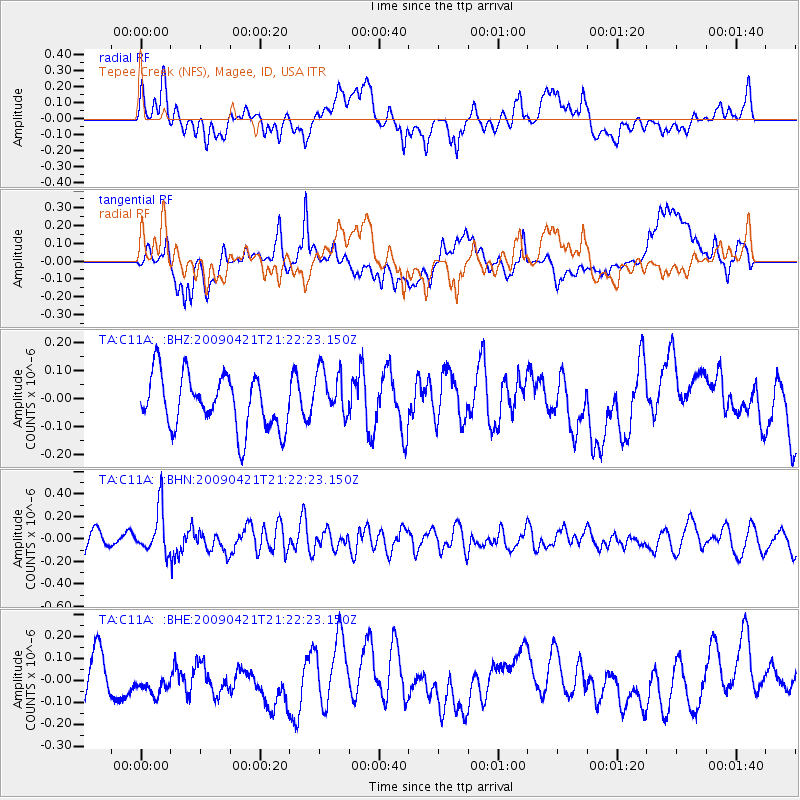
C11A Tepee Creek (NFS), Magee, ID, USA - Earthquake Result Viewer
*The percent match for this event was below the threshold and hence no stack was calculated.
| Earthquake location: |
Santa Cruz Islands |
| Earthquake latitude/longitude: |
-10.8/166.0 |
| Earthquake time(UTC): |
2009/04/21 (111) 21:09:59 GMT |
| Earthquake Depth: |
35 km |
| Earthquake Magnitude: |
5.7 MW, 5.0 MS, 5.3 MB, 5.7 MW |
| Earthquake Catalog/Contributor: |
WHDF/NEIC |
|
| Network: |
TA USArray Transportable Network (new EarthScope stations) |
| Station: |
C11A Tepee Creek (NFS), Magee, ID, USA |
| Lat/Lon: |
47.84 N/116.26 W |
| Elevation: |
914 m |
|
| Distance: |
89.8 deg |
| Az: |
41.167 deg |
| Baz: |
253.748 deg |
| Ray Param: |
$rayparam |
*The percent match for this event was below the threshold and hence was not used in the summary stack. |
|
| Radial Match: |
46.296894 % |
| Radial Bump: |
400 |
| Transverse Match: |
50.2322 % |
| Transverse Bump: |
400 |
| SOD ConfigId: |
2658 |
| Insert Time: |
2010-03-06 13:41:12.194 +0000 |
| GWidth: |
2.5 |
| Max Bumps: |
400 |
| Tol: |
0.001 |
|
Signal To Noise
| Channel | StoN | STA | LTA |
| TA:C11A: :BHN:20090421T21:22:23.150Z | 3.016051 | 1.996114E-7 | 6.6183034E-8 |
| TA:C11A: :BHE:20090421T21:22:23.150Z | 0.7849467 | 7.2670744E-8 | 9.2580486E-8 |
| TA:C11A: :BHZ:20090421T21:22:23.150Z | 0.9634678 | 8.974335E-8 | 9.314619E-8 |
| Arrivals |
| Ps | |
| PpPs | |
| PsPs/PpSs | |


