You are here: Home > Network List > N4 - Central and EAstern US Network Stations List
> Station L59A Walton, NY, USA > Earthquake Result Viewer
L59A Walton, NY, USA - Earthquake Result Viewer
| Earthquake location: |
Kuril Islands |
| Earthquake latitude/longitude: |
48.5/154.8 |
| Earthquake time(UTC): |
2018/08/10 (222) 18:12:05 GMT |
| Earthquake Depth: |
16 km |
| Earthquake Magnitude: |
5.9 Mww |
| Earthquake Catalog/Contributor: |
NEIC PDE/us |
|
| Network: |
N4 Central and EAstern US Network |
| Station: |
L59A Walton, NY, USA |
| Lat/Lon: |
42.19 N/75.04 W |
| Elevation: |
677 m |
|
| Distance: |
79.6 deg |
| Az: |
35.255 deg |
| Baz: |
328.876 deg |
| Ray Param: |
0.048830304 |
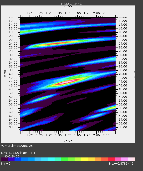
| Estimated Moho Depth: |
44.0 km |
| Estimated Crust Vp/Vs: |
1.84 |
| Assumed Crust Vp: |
6.419 km/s |
| Estimated Crust Vs: |
3.484 km/s |
| Estimated Crust Poisson's Ratio: |
0.29 |
|
| Radial Match: |
88.056725 % |
| Radial Bump: |
301 |
| Transverse Match: |
74.09996 % |
| Transverse Bump: |
400 |
| SOD ConfigId: |
13570011 |
| Insert Time: |
2019-04-30 18:36:01.808 +0000 |
| GWidth: |
2.5 |
| Max Bumps: |
400 |
| Tol: |
0.001 |
|

Signal To Noise
| Channel | StoN | STA | LTA |
| N4:L59A: :HHZ:20180810T18:23:40.280027Z | 7.820126 | 7.616816E-7 | 9.740016E-8 |
| N4:L59A: :HHN:20180810T18:23:40.280027Z | 2.4160218 | 2.9123967E-7 | 1.2054514E-7 |
| N4:L59A: :HHE:20180810T18:23:40.280027Z | 2.5882328 | 1.3782675E-7 | 5.3251295E-8 |
| Arrivals |
| Ps | 5.9 SECOND |
| PpPs | 19 SECOND |
| PsPs/PpSs | 25 SECOND |


