You are here: Home > Network List > N4 - Central and EAstern US Network Stations List
> Station N35B Tabor, IA, USA > Earthquake Result Viewer
N35B Tabor, IA, USA - Earthquake Result Viewer
| Earthquake location: |
Kuril Islands |
| Earthquake latitude/longitude: |
48.5/154.8 |
| Earthquake time(UTC): |
2018/08/10 (222) 18:12:05 GMT |
| Earthquake Depth: |
16 km |
| Earthquake Magnitude: |
5.9 Mww |
| Earthquake Catalog/Contributor: |
NEIC PDE/us |
|
| Network: |
N4 Central and EAstern US Network |
| Station: |
N35B Tabor, IA, USA |
| Lat/Lon: |
40.86 N/95.64 W |
| Elevation: |
353 m |
|
| Distance: |
71.5 deg |
| Az: |
48.895 deg |
| Baz: |
318.612 deg |
| Ray Param: |
0.05427257 |
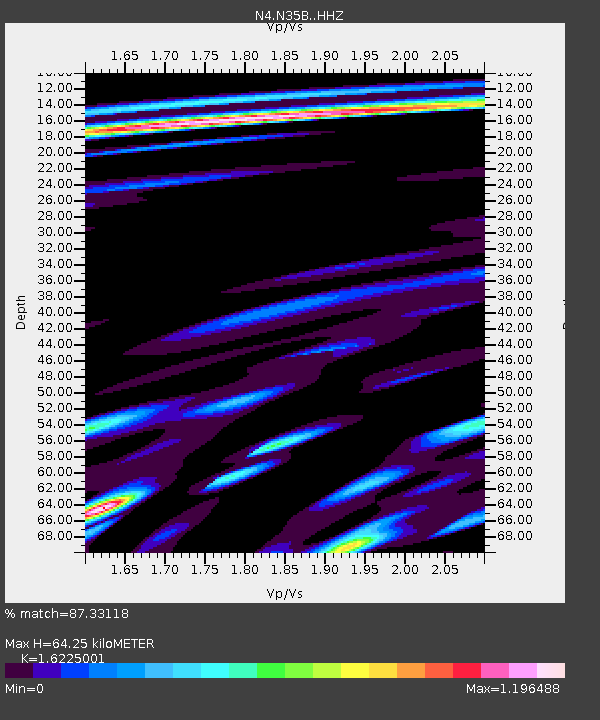
| Estimated Moho Depth: |
64.25 km |
| Estimated Crust Vp/Vs: |
1.62 |
| Assumed Crust Vp: |
6.498 km/s |
| Estimated Crust Vs: |
4.005 km/s |
| Estimated Crust Poisson's Ratio: |
0.19 |
|
| Radial Match: |
87.33118 % |
| Radial Bump: |
400 |
| Transverse Match: |
66.58816 % |
| Transverse Bump: |
400 |
| SOD ConfigId: |
13570011 |
| Insert Time: |
2019-04-30 18:36:07.502 +0000 |
| GWidth: |
2.5 |
| Max Bumps: |
400 |
| Tol: |
0.001 |
|

Signal To Noise
| Channel | StoN | STA | LTA |
| N4:N35B: :HHZ:20180810T18:22:53.799985Z | 14.108515 | 1.3943883E-6 | 9.8833105E-8 |
| N4:N35B: :HHN:20180810T18:22:53.799985Z | 4.198973 | 4.9018854E-7 | 1.16740104E-7 |
| N4:N35B: :HHE:20180810T18:22:53.799985Z | 3.155737 | 3.7197387E-7 | 1.1787227E-7 |
| Arrivals |
| Ps | 6.4 SECOND |
| PpPs | 25 SECOND |
| PsPs/PpSs | 31 SECOND |


