You are here: Home > Network List > N4 - Central and EAstern US Network Stations List
> Station P48A Milroy, IN, USA > Earthquake Result Viewer
P48A Milroy, IN, USA - Earthquake Result Viewer
| Earthquake location: |
Kuril Islands |
| Earthquake latitude/longitude: |
48.5/154.8 |
| Earthquake time(UTC): |
2018/08/10 (222) 18:12:05 GMT |
| Earthquake Depth: |
16 km |
| Earthquake Magnitude: |
5.9 Mww |
| Earthquake Catalog/Contributor: |
NEIC PDE/us |
|
| Network: |
N4 Central and EAstern US Network |
| Station: |
P48A Milroy, IN, USA |
| Lat/Lon: |
39.46 N/85.43 W |
| Elevation: |
300 m |
|
| Distance: |
77.5 deg |
| Az: |
43.478 deg |
| Baz: |
323.735 deg |
| Ray Param: |
0.050268587 |
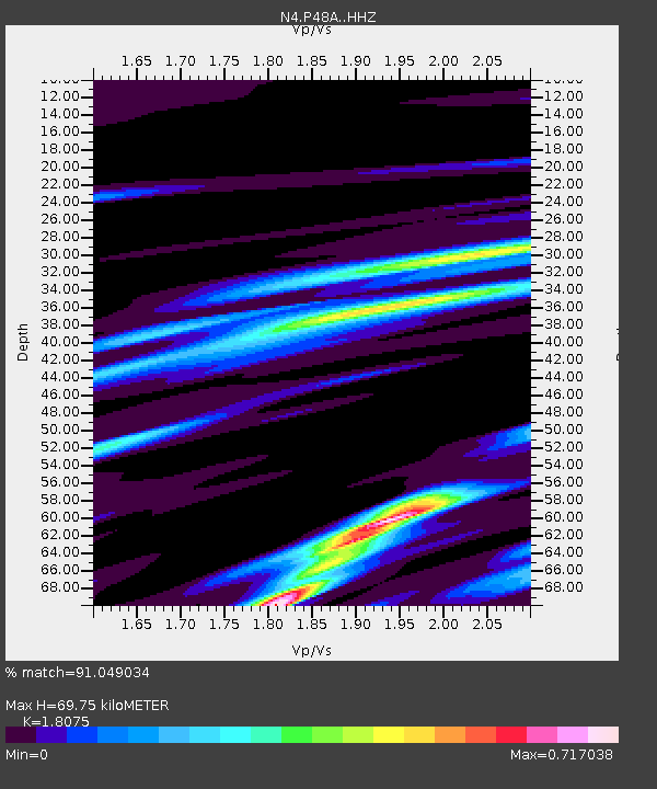
| Estimated Moho Depth: |
69.75 km |
| Estimated Crust Vp/Vs: |
1.81 |
| Assumed Crust Vp: |
6.498 km/s |
| Estimated Crust Vs: |
3.595 km/s |
| Estimated Crust Poisson's Ratio: |
0.28 |
|
| Radial Match: |
91.049034 % |
| Radial Bump: |
400 |
| Transverse Match: |
73.6319 % |
| Transverse Bump: |
400 |
| SOD ConfigId: |
13570011 |
| Insert Time: |
2019-04-30 18:36:18.813 +0000 |
| GWidth: |
2.5 |
| Max Bumps: |
400 |
| Tol: |
0.001 |
|

Signal To Noise
| Channel | StoN | STA | LTA |
| N4:P48A: :HHZ:20180810T18:23:28.609983Z | 14.317858 | 1.1543502E-6 | 8.062311E-8 |
| N4:P48A: :HHN:20180810T18:23:28.609983Z | 3.878277 | 3.2493776E-7 | 8.378405E-8 |
| N4:P48A: :HHE:20180810T18:23:28.609983Z | 4.8726783 | 2.923187E-7 | 5.9991386E-8 |
| Arrivals |
| Ps | 8.9 SECOND |
| PpPs | 29 SECOND |
| PsPs/PpSs | 38 SECOND |


