You are here: Home > Network List > NM - Cooperative New Madrid Seismic Network Stations List
> Station BLO Bloomington, IN > Earthquake Result Viewer
BLO Bloomington, IN - Earthquake Result Viewer
| Earthquake location: |
Kuril Islands |
| Earthquake latitude/longitude: |
48.5/154.8 |
| Earthquake time(UTC): |
2018/08/10 (222) 18:12:05 GMT |
| Earthquake Depth: |
16 km |
| Earthquake Magnitude: |
5.9 Mww |
| Earthquake Catalog/Contributor: |
NEIC PDE/us |
|
| Network: |
NM Cooperative New Madrid Seismic Network |
| Station: |
BLO Bloomington, IN |
| Lat/Lon: |
39.17 N/86.52 W |
| Elevation: |
246 m |
|
| Distance: |
77.2 deg |
| Az: |
44.355 deg |
| Baz: |
323.235 deg |
| Ray Param: |
0.05045468 |
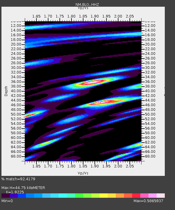
| Estimated Moho Depth: |
44.75 km |
| Estimated Crust Vp/Vs: |
1.92 |
| Assumed Crust Vp: |
6.444 km/s |
| Estimated Crust Vs: |
3.352 km/s |
| Estimated Crust Poisson's Ratio: |
0.31 |
|
| Radial Match: |
92.4179 % |
| Radial Bump: |
400 |
| Transverse Match: |
82.87569 % |
| Transverse Bump: |
400 |
| SOD ConfigId: |
13570011 |
| Insert Time: |
2019-04-30 18:37:02.408 +0000 |
| GWidth: |
2.5 |
| Max Bumps: |
400 |
| Tol: |
0.001 |
|

Signal To Noise
| Channel | StoN | STA | LTA |
| NM:BLO: :HHZ:20180810T18:23:27.070005Z | 8.7270775 | 8.920262E-7 | 1.0221362E-7 |
| NM:BLO: :HHN:20180810T18:23:27.070005Z | 3.2403865 | 2.2996394E-7 | 7.096806E-8 |
| NM:BLO: :HHE:20180810T18:23:27.070005Z | 2.866383 | 1.5918695E-7 | 5.553583E-8 |
| Arrivals |
| Ps | 6.6 SECOND |
| PpPs | 20 SECOND |
| PsPs/PpSs | 26 SECOND |


