You are here: Home > Network List > NN - Western Great Basin/Eastern Sierra Nevada Stations List
> Station ZPR Zephyr Cove, Lake Tahoe, Nevada > Earthquake Result Viewer
ZPR Zephyr Cove, Lake Tahoe, Nevada - Earthquake Result Viewer
| Earthquake location: |
Kuril Islands |
| Earthquake latitude/longitude: |
48.5/154.8 |
| Earthquake time(UTC): |
2018/08/10 (222) 18:12:05 GMT |
| Earthquake Depth: |
16 km |
| Earthquake Magnitude: |
5.9 Mww |
| Earthquake Catalog/Contributor: |
NEIC PDE/us |
|
| Network: |
NN Western Great Basin/Eastern Sierra Nevada |
| Station: |
ZPR Zephyr Cove, Lake Tahoe, Nevada |
| Lat/Lon: |
39.01 N/119.94 W |
| Elevation: |
2001 m |
|
| Distance: |
59.3 deg |
| Az: |
64.552 deg |
| Baz: |
309.524 deg |
| Ray Param: |
0.062265527 |
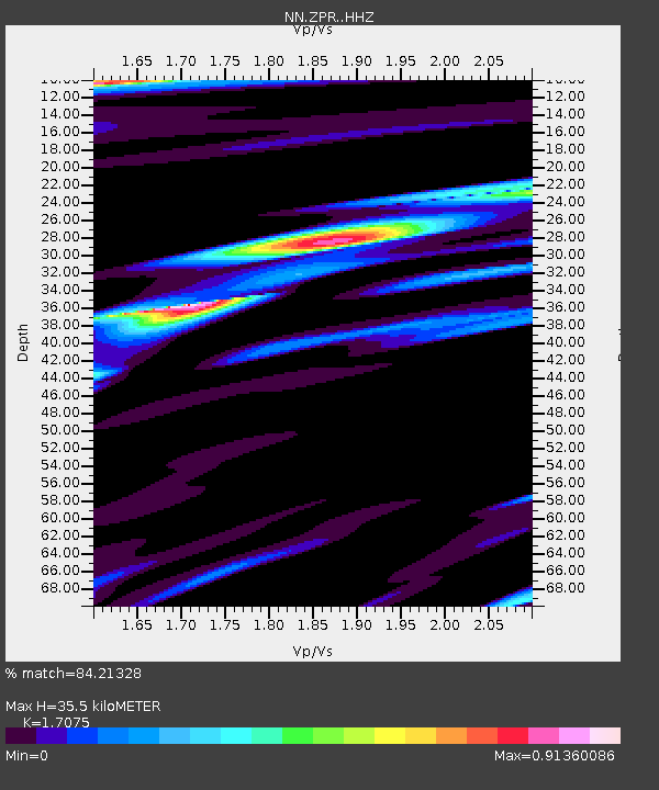
| Estimated Moho Depth: |
35.5 km |
| Estimated Crust Vp/Vs: |
1.71 |
| Assumed Crust Vp: |
6.279 km/s |
| Estimated Crust Vs: |
3.677 km/s |
| Estimated Crust Poisson's Ratio: |
0.24 |
|
| Radial Match: |
84.21328 % |
| Radial Bump: |
400 |
| Transverse Match: |
77.2863 % |
| Transverse Bump: |
400 |
| SOD ConfigId: |
13570011 |
| Insert Time: |
2019-04-30 18:37:33.100 +0000 |
| GWidth: |
2.5 |
| Max Bumps: |
400 |
| Tol: |
0.001 |
|

Signal To Noise
| Channel | StoN | STA | LTA |
| NN:ZPR: :HHZ:20180810T18:21:34.84802Z | 12.451757 | 9.325269E-7 | 7.489119E-8 |
| NN:ZPR: :HHN:20180810T18:21:34.84802Z | 4.066332 | 2.7117892E-7 | 6.6688834E-8 |
| NN:ZPR: :HHE:20180810T18:21:34.84802Z | 5.3924394 | 3.5755562E-7 | 6.630684E-8 |
| Arrivals |
| Ps | 4.2 SECOND |
| PpPs | 15 SECOND |
| PsPs/PpSs | 19 SECOND |


