You are here: Home > Network List > OH - Ohio Seismic Network Stations List
> Station SSFO Shawnee State Forest Ohio > Earthquake Result Viewer
SSFO Shawnee State Forest Ohio - Earthquake Result Viewer
| Earthquake location: |
Kuril Islands |
| Earthquake latitude/longitude: |
48.5/154.8 |
| Earthquake time(UTC): |
2018/08/10 (222) 18:12:05 GMT |
| Earthquake Depth: |
16 km |
| Earthquake Magnitude: |
5.9 Mww |
| Earthquake Catalog/Contributor: |
NEIC PDE/us |
|
| Network: |
OH Ohio Seismic Network |
| Station: |
SSFO Shawnee State Forest Ohio |
| Lat/Lon: |
38.70 N/83.20 W |
| Elevation: |
365 m |
|
| Distance: |
79.1 deg |
| Az: |
42.494 deg |
| Baz: |
324.935 deg |
| Ray Param: |
0.049158845 |
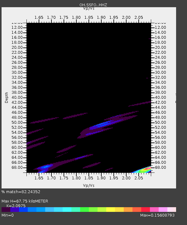
| Estimated Moho Depth: |
67.75 km |
| Estimated Crust Vp/Vs: |
2.10 |
| Assumed Crust Vp: |
6.232 km/s |
| Estimated Crust Vs: |
2.971 km/s |
| Estimated Crust Poisson's Ratio: |
0.35 |
|
| Radial Match: |
82.24352 % |
| Radial Bump: |
298 |
| Transverse Match: |
67.087105 % |
| Transverse Bump: |
400 |
| SOD ConfigId: |
13570011 |
| Insert Time: |
2019-04-30 18:37:54.217 +0000 |
| GWidth: |
2.5 |
| Max Bumps: |
400 |
| Tol: |
0.001 |
|

Signal To Noise
| Channel | StoN | STA | LTA |
| OH:SSFO: :HHZ:20180810T18:23:37.609983Z | 3.746395 | 1.4936758E-6 | 3.986968E-7 |
| OH:SSFO: :HHN:20180810T18:23:37.609983Z | 4.507053 | 6.8747295E-7 | 1.525327E-7 |
| OH:SSFO: :HHE:20180810T18:23:37.609983Z | 0.93378896 | 2.3303151E-7 | 2.495548E-7 |
| Arrivals |
| Ps | 12 SECOND |
| PpPs | 33 SECOND |
| PsPs/PpSs | 45 SECOND |


