You are here: Home > Network List > CI - Caltech Regional Seismic Network Stations List
> Station PHL Parkhill, California, USA > Earthquake Result Viewer
PHL Parkhill, California, USA - Earthquake Result Viewer
| Earthquake location: |
Near Coast Of Central Chile |
| Earthquake latitude/longitude: |
-29.5/-71.7 |
| Earthquake time(UTC): |
1998/09/03 (246) 17:37:58 GMT |
| Earthquake Depth: |
27 km |
| Earthquake Magnitude: |
6.2 MB, 6.6 MS, 6.5 UNKNOWN, 6.4 ME |
| Earthquake Catalog/Contributor: |
WHDF/NEIC |
|
| Network: |
CI Caltech Regional Seismic Network |
| Station: |
PHL Parkhill, California, USA |
| Lat/Lon: |
35.41 N/120.55 W |
| Elevation: |
351 m |
|
| Distance: |
79.2 deg |
| Az: |
321.249 deg |
| Baz: |
138.062 deg |
| Ray Param: |
0.04907005 |
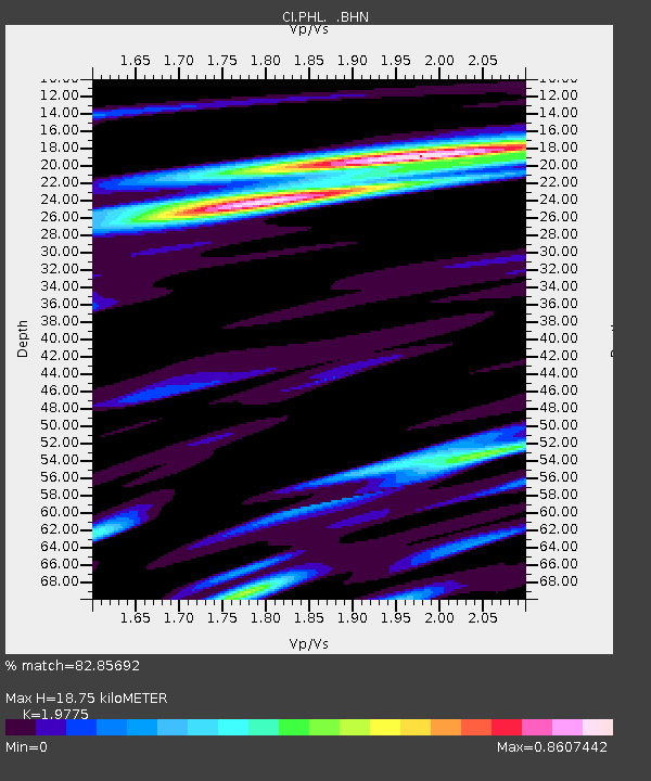
| Estimated Moho Depth: |
18.75 km |
| Estimated Crust Vp/Vs: |
1.98 |
| Assumed Crust Vp: |
6.183 km/s |
| Estimated Crust Vs: |
3.126 km/s |
| Estimated Crust Poisson's Ratio: |
0.33 |
|
| Radial Match: |
82.85692 % |
| Radial Bump: |
400 |
| Transverse Match: |
82.167175 % |
| Transverse Bump: |
400 |
| SOD ConfigId: |
3770 |
| Insert Time: |
2010-02-26 02:10:53.702 +0000 |
| GWidth: |
2.5 |
| Max Bumps: |
400 |
| Tol: |
0.001 |
|
Signal To Noise
| Channel | StoN | STA | LTA |
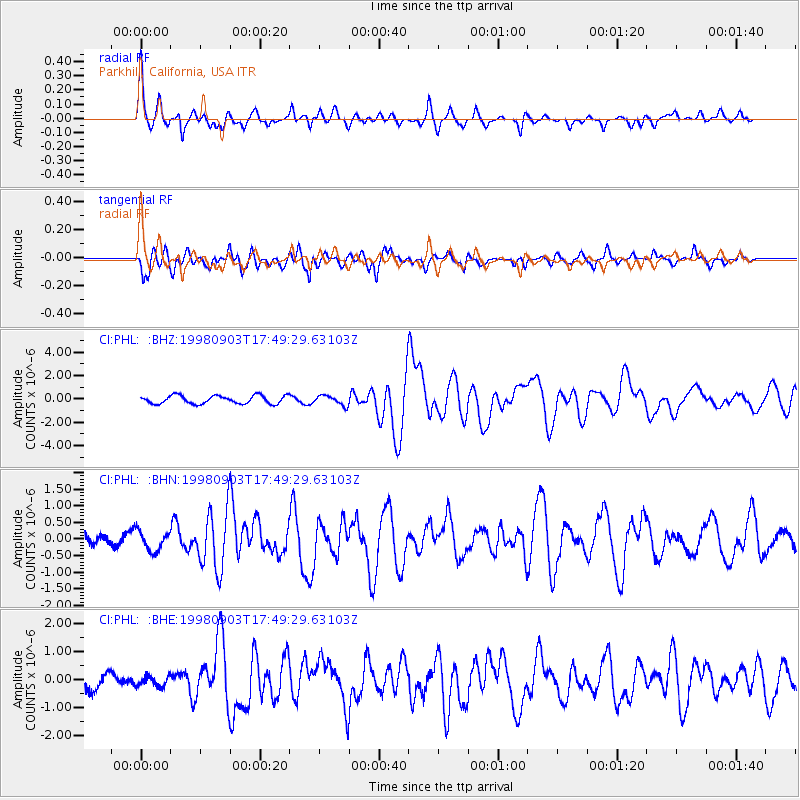
| CI:PHL: :BHN:19980903T17:49:29.63103Z | 1.3628091 | 2.9254824E-7 | 2.146656E-7 |
| CI:PHL: :BHE:19980903T17:49:29.63103Z | 0.39844012 | 1.8175696E-7 | 4.5617134E-7 |
| CI:PHL: :BHZ:19980903T17:49:29.63103Z | 1.1974287 | 4.1401557E-7 | 3.4575385E-7 |
| Arrivals |
| Ps | 3.0 SECOND |
| PpPs | 8.8 SECOND |
| PsPs/PpSs | 12 SECOND |


