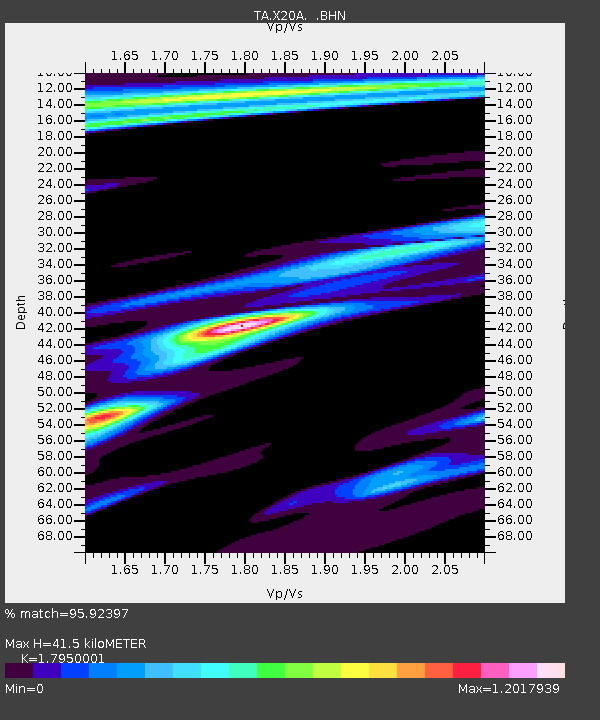
X20A Quemado, NM, USA - Earthquake Result Viewer
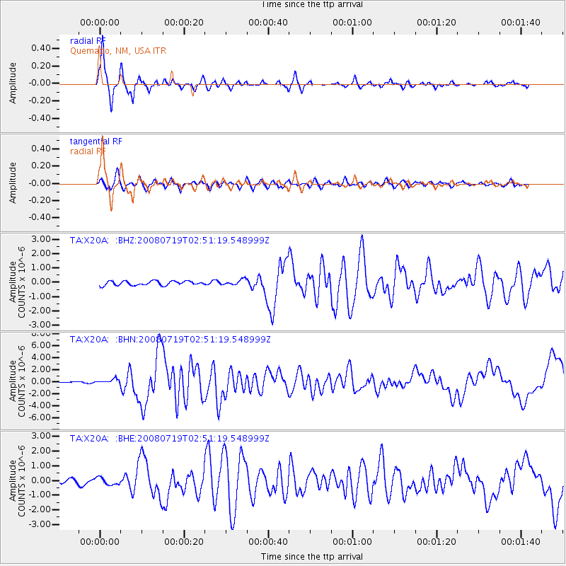
Earthquake location: Off East Coast Of Honshu, Japan
Earthquake latitude/longitude: 37.6/142.2
Earthquake time(UTC): 2008/07/19 (201) 02:39:28 GMT
Earthquake Depth: 22 km
Earthquake Magnitude: 6.2 MB, 7.0 MS, 7.0 MW, 6.9 MW
Earthquake Catalog/Contributor: WHDF/NEIC
Network: TA USArray Transportable Network (new EarthScope stations)
Station: X20A Quemado, NM, USA
Lat/Lon: 34.54 N/108.50 W
Elevation: 2057 m
Distance: 82.8 deg
Az: 51.757 deg
Baz: 310.872 deg
Ray Param: 0.046634667
Estimated Moho Depth: 41.5 km
Estimated Crust Vp/Vs: 1.80
Assumed Crust Vp: 6.496 km/s
Estimated Crust Vs: 3.619 km/s
Estimated Crust Poisson's Ratio: 0.27
Radial Match: 95.92397 %
Radial Bump: 323
Transverse Match: 87.95798 %
Transverse Bump: 400
SOD ConfigId: 2504
Insert Time: 2010-03-06 13:41:58.998 +0000
GWidth: 2.5
Max Bumps: 400
Tol: 0.001

Signal To Noise

ChannelStoNSTALTA
TA:X20A: :BHN:20080719T02:51:19.548999Z4.6734423.8381788E-78.212745E-8
TA:X20A: :BHE:20080719T02:51:19.548999Z2.6651282.4808983E-79.3087394E-8
TA:X20A: :BHZ:20080719T02:51:19.548999Z1.36103561.9821711E-71.4563697E-7
Arrivals
Ps5.2 SECOND
PpPs17 SECOND
PsPs/PpSs23 SECOND