You are here: Home > Network List > TA - USArray Transportable Network (new EarthScope stations) Stations List
> Station C24K Franklin Bluffs, AK, USA > Earthquake Result Viewer
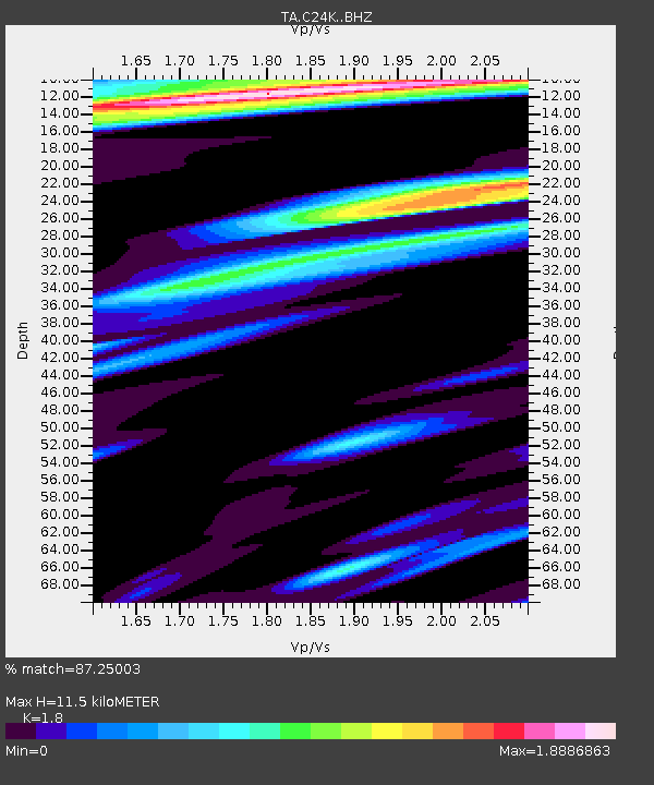
C24K Franklin Bluffs, AK, USA - Earthquake Result Viewer
| Earthquake location: |
Kuril Islands |
| Earthquake latitude/longitude: |
48.5/154.8 |
| Earthquake time(UTC): |
2018/08/10 (222) 18:12:05 GMT |
| Earthquake Depth: |
16 km |
| Earthquake Magnitude: |
5.9 Mww |
| Earthquake Catalog/Contributor: |
NEIC PDE/us |
|
| Network: |
TA USArray Transportable Network (new EarthScope stations) |
| Station: |
C24K Franklin Bluffs, AK, USA |
| Lat/Lon: |
69.72 N/148.70 W |
| Elevation: |
115 m |
|
| Distance: |
34.2 deg |
| Az: |
31.201 deg |
| Baz: |
261.416 deg |
| Ray Param: |
0.07786589 |
| Estimated Moho Depth: |
11.5 km |
| Estimated Crust Vp/Vs: |
1.80 |
| Assumed Crust Vp: |
6.316 km/s |
| Estimated Crust Vs: |
3.509 km/s |
| Estimated Crust Poisson's Ratio: |
0.28 |
|
| Radial Match: |
87.25003 % |
| Radial Bump: |
396 |
| Transverse Match: |
82.2577 % |
| Transverse Bump: |
400 |
| SOD ConfigId: |
13570011 |
| Insert Time: |
2019-04-30 18:39:46.498 +0000 |
| GWidth: |
2.5 |
| Max Bumps: |
400 |
| Tol: |
0.001 |
|

Signal To Noise
| Channel | StoN | STA | LTA |
| TA:C24K: :BHZ:20180810T18:18:18.924985Z | 20.78539 | 1.8789156E-6 | 9.0395964E-8 |
| TA:C24K: :BHN:20180810T18:18:18.924985Z | 2.7100482 | 1.8496019E-7 | 6.8249776E-8 |
| TA:C24K: :BHE:20180810T18:18:18.924985Z | 1.8808336 | 2.9611175E-7 | 1.5743645E-7 |
| Arrivals |
| Ps | 1.6 SECOND |
| PpPs | 4.7 SECOND |
| PsPs/PpSs | 6.3 SECOND |


