You are here: Home > Network List > TA - USArray Transportable Network (new EarthScope stations) Stations List
> Station D20K Etivluk River, AK, USA > Earthquake Result Viewer
D20K Etivluk River, AK, USA - Earthquake Result Viewer
| Earthquake location: |
Kuril Islands |
| Earthquake latitude/longitude: |
48.5/154.8 |
| Earthquake time(UTC): |
2018/08/10 (222) 18:12:05 GMT |
| Earthquake Depth: |
16 km |
| Earthquake Magnitude: |
5.9 Mww |
| Earthquake Catalog/Contributor: |
NEIC PDE/us |
|
| Network: |
TA USArray Transportable Network (new EarthScope stations) |
| Station: |
D20K Etivluk River, AK, USA |
| Lat/Lon: |
68.71 N/156.61 W |
| Elevation: |
577 m |
|
| Distance: |
31.2 deg |
| Az: |
31.946 deg |
| Baz: |
254.651 deg |
| Ray Param: |
0.07912916 |
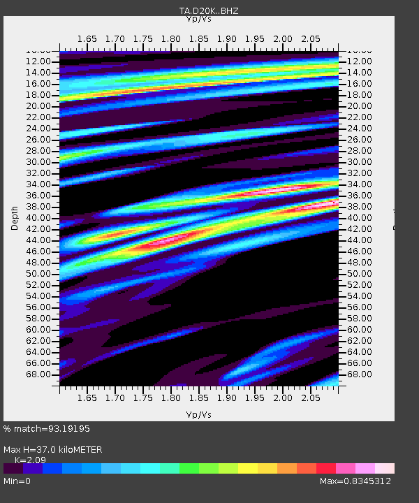
| Estimated Moho Depth: |
37.0 km |
| Estimated Crust Vp/Vs: |
2.09 |
| Assumed Crust Vp: |
6.221 km/s |
| Estimated Crust Vs: |
2.977 km/s |
| Estimated Crust Poisson's Ratio: |
0.35 |
|
| Radial Match: |
93.19195 % |
| Radial Bump: |
400 |
| Transverse Match: |
84.47686 % |
| Transverse Bump: |
400 |
| SOD ConfigId: |
13570011 |
| Insert Time: |
2019-04-30 18:39:51.370 +0000 |
| GWidth: |
2.5 |
| Max Bumps: |
400 |
| Tol: |
0.001 |
|

Signal To Noise
| Channel | StoN | STA | LTA |
| TA:D20K: :BHZ:20180810T18:17:52.999998Z | 24.804688 | 1.6585503E-6 | 6.6864395E-8 |
| TA:D20K: :BHN:20180810T18:17:52.999998Z | 4.4286623 | 3.13113E-7 | 7.070148E-8 |
| TA:D20K: :BHE:20180810T18:17:52.999998Z | 15.561172 | 8.1606197E-7 | 5.2442196E-8 |
| Arrivals |
| Ps | 6.9 SECOND |
| PpPs | 17 SECOND |
| PsPs/PpSs | 24 SECOND |


