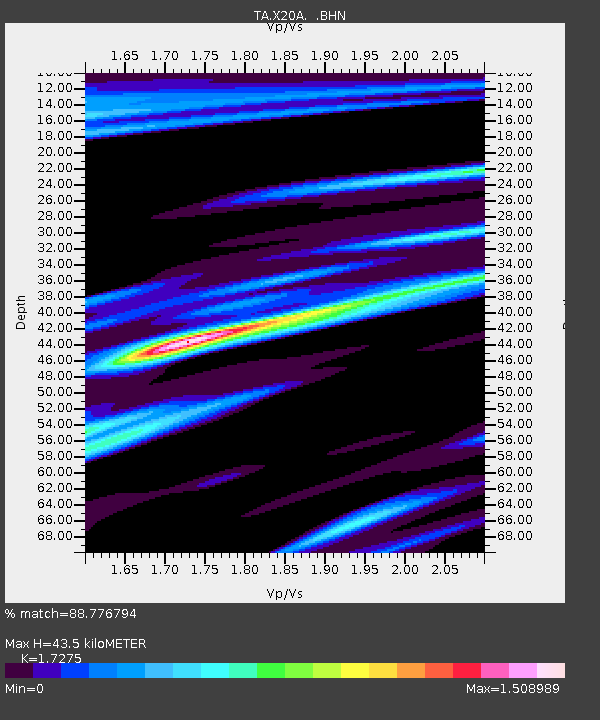
X20A Quemado, NM, USA - Earthquake Result Viewer
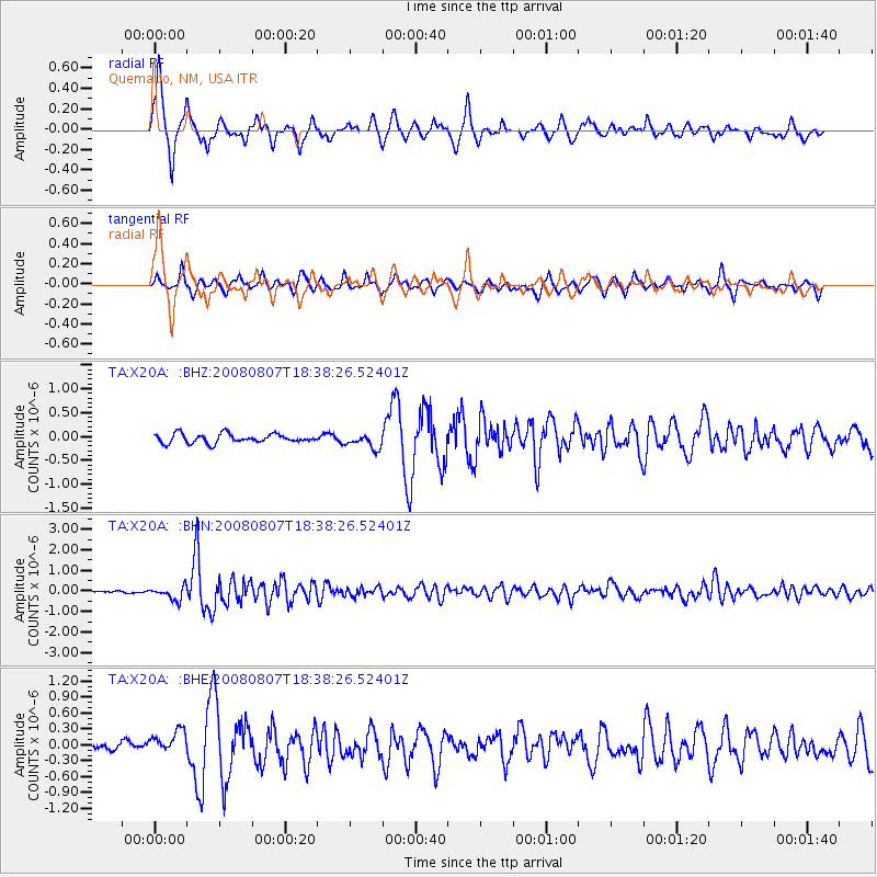
Earthquake location: Andreanof Islands, Aleutian Is.
Earthquake latitude/longitude: 52.2/-175.7
Earthquake time(UTC): 2008/08/07 (220) 18:30:03 GMT
Earthquake Depth: 12 km
Earthquake Magnitude: 5.6 MB, 5.5 MS, 5.8 MW, 5.8 MW
Earthquake Catalog/Contributor: WHDF/NEIC
Network: TA USArray Transportable Network (new EarthScope stations)
Station: X20A Quemado, NM, USA
Lat/Lon: 34.54 N/108.50 W
Elevation: 2057 m
Distance: 50.1 deg
Az: 82.89 deg
Baz: 312.266 deg
Ray Param: 0.068305835
Estimated Moho Depth: 43.5 km
Estimated Crust Vp/Vs: 1.73
Assumed Crust Vp: 6.496 km/s
Estimated Crust Vs: 3.76 km/s
Estimated Crust Poisson's Ratio: 0.25
Radial Match: 88.776794 %
Radial Bump: 400
Transverse Match: 80.99659 %
Transverse Bump: 400
SOD ConfigId: 2504
Insert Time: 2010-03-06 13:42:09.047 +0000
GWidth: 2.5
Max Bumps: 400
Tol: 0.001

Signal To Noise

ChannelStoNSTALTA
TA:X20A: :BHN:20080807T18:38:26.52401Z6.896563.226321E-74.6781597E-8
TA:X20A: :BHE:20080807T18:38:26.52401Z3.05211282.4202765E-77.92984E-8
TA:X20A: :BHZ:20080807T18:38:26.52401Z1.60720791.5046105E-79.361642E-8
Arrivals
Ps5.2 SECOND
PpPs17 SECOND
PsPs/PpSs22 SECOND