You are here: Home > Network List > TA - USArray Transportable Network (new EarthScope stations) Stations List
> Station X20A Quemado, NM, USA > Earthquake Result Viewer
X20A Quemado, NM, USA - Earthquake Result Viewer
| Earthquake location: |
Tonga Islands |
| Earthquake latitude/longitude: |
-21.9/-173.8 |
| Earthquake time(UTC): |
2008/10/19 (293) 05:10:33 GMT |
| Earthquake Depth: |
29 km |
| Earthquake Magnitude: |
6.8 MB, 7.0 MS, 6.9 MW, 6.9 MW |
| Earthquake Catalog/Contributor: |
WHDF/NEIC |
|
| Network: |
TA USArray Transportable Network (new EarthScope stations) |
| Station: |
X20A Quemado, NM, USA |
| Lat/Lon: |
34.54 N/108.50 W |
| Elevation: |
2057 m |
|
| Distance: |
83.6 deg |
| Az: |
49.005 deg |
| Baz: |
238.142 deg |
| Ray Param: |
0.04602581 |
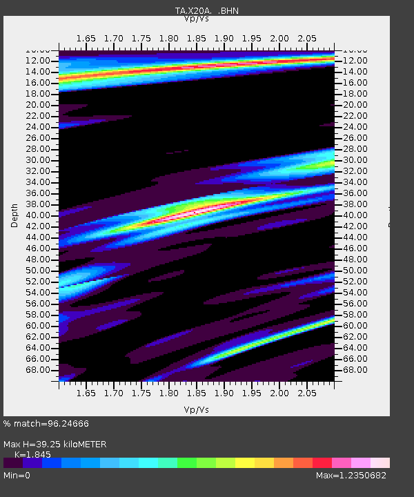
| Estimated Moho Depth: |
39.25 km |
| Estimated Crust Vp/Vs: |
1.85 |
| Assumed Crust Vp: |
6.496 km/s |
| Estimated Crust Vs: |
3.521 km/s |
| Estimated Crust Poisson's Ratio: |
0.29 |
|
| Radial Match: |
96.24666 % |
| Radial Bump: |
310 |
| Transverse Match: |
90.45035 % |
| Transverse Bump: |
398 |
| SOD ConfigId: |
2556 |
| Insert Time: |
2010-03-06 13:42:14.636 +0000 |
| GWidth: |
2.5 |
| Max Bumps: |
400 |
| Tol: |
0.001 |
|
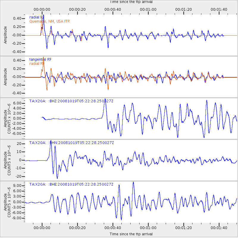
Signal To Noise
| Channel | StoN | STA | LTA |
| TA:X20A: :BHN:20081019T05:22:28.250027Z | 88.31745 | 6.1308883E-6 | 6.941876E-8 |
| TA:X20A: :BHE:20081019T05:22:28.250027Z | 2.975055 | 5.755636E-7 | 1.934632E-7 |
| TA:X20A: :BHZ:20081019T05:22:28.250027Z | 5.4185495 | 9.211726E-7 | 1.7000355E-7 |
| Arrivals |
| Ps | 5.2 SECOND |
| PpPs | 17 SECOND |
| PsPs/PpSs | 22 SECOND |


