You are here: Home > Network List > TA - USArray Transportable Network (new EarthScope stations) Stations List
> Station G26K Porcupine River, AK, USA > Earthquake Result Viewer
G26K Porcupine River, AK, USA - Earthquake Result Viewer
| Earthquake location: |
Kuril Islands |
| Earthquake latitude/longitude: |
48.5/154.8 |
| Earthquake time(UTC): |
2018/08/10 (222) 18:12:05 GMT |
| Earthquake Depth: |
16 km |
| Earthquake Magnitude: |
5.9 Mww |
| Earthquake Catalog/Contributor: |
NEIC PDE/us |
|
| Network: |
TA USArray Transportable Network (new EarthScope stations) |
| Station: |
G26K Porcupine River, AK, USA |
| Lat/Lon: |
66.95 N/143.78 W |
| Elevation: |
180 m |
|
| Distance: |
35.8 deg |
| Az: |
36.276 deg |
| Baz: |
270.144 deg |
| Ray Param: |
0.07703003 |
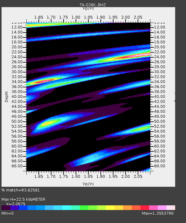
| Estimated Moho Depth: |
22.5 km |
| Estimated Crust Vp/Vs: |
2.10 |
| Assumed Crust Vp: |
6.577 km/s |
| Estimated Crust Vs: |
3.136 km/s |
| Estimated Crust Poisson's Ratio: |
0.35 |
|
| Radial Match: |
93.62561 % |
| Radial Bump: |
391 |
| Transverse Match: |
88.84585 % |
| Transverse Bump: |
400 |
| SOD ConfigId: |
13570011 |
| Insert Time: |
2019-04-30 18:40:14.955 +0000 |
| GWidth: |
2.5 |
| Max Bumps: |
400 |
| Tol: |
0.001 |
|

Signal To Noise
| Channel | StoN | STA | LTA |
| TA:G26K: :BHZ:20180810T18:18:32.749998Z | 28.270357 | 1.9299493E-6 | 6.8267596E-8 |
| TA:G26K: :BHN:20180810T18:18:32.749998Z | 11.262325 | 6.5662846E-7 | 5.8303097E-8 |
| TA:G26K: :BHE:20180810T18:18:32.749998Z | 19.374746 | 1.2998797E-6 | 6.709145E-8 |
| Arrivals |
| Ps | 4.0 SECOND |
| PpPs | 9.9 SECOND |
| PsPs/PpSs | 14 SECOND |


