You are here: Home > Network List > CI - Caltech Regional Seismic Network Stations List
> Station PHL Parkhill, California, USA > Earthquake Result Viewer
PHL Parkhill, California, USA - Earthquake Result Viewer

| Earthquake location: |
Peru-Brazil Border Region |
| Earthquake latitude/longitude: |
-8.1/-74.2 |
| Earthquake time(UTC): |
1998/04/03 (093) 22:01:48 GMT |
| Earthquake Depth: |
165 km |
| Earthquake Magnitude: |
6.1 MB, 5.6 MS, 6.6 UNKNOWN, 6.6 MW |
| Earthquake Catalog/Contributor: |
WHDF/NEIC |
|
| Network: |
CI Caltech Regional Seismic Network |
| Station: |
PHL Parkhill, California, USA |
| Lat/Lon: |
35.41 N/120.55 W |
| Elevation: |
351 m |
|
| Distance: |
61.5 deg |
| Az: |
317.762 deg |
| Baz: |
125.441 deg |
| Ray Param: |
0.060351312 |
| Estimated Moho Depth: |
24.0 km |
| Estimated Crust Vp/Vs: |
1.75 |
| Assumed Crust Vp: |
6.183 km/s |
| Estimated Crust Vs: |
3.533 km/s |
| Estimated Crust Poisson's Ratio: |
0.26 |
|
| Radial Match: |
84.29934 % |
| Radial Bump: |
400 |
| Transverse Match: |
78.48558 % |
| Transverse Bump: |
400 |
| SOD ConfigId: |
3770 |
| Insert Time: |
2010-02-26 02:10:54.822 +0000 |
| GWidth: |
2.5 |
| Max Bumps: |
400 |
| Tol: |
0.001 |
|
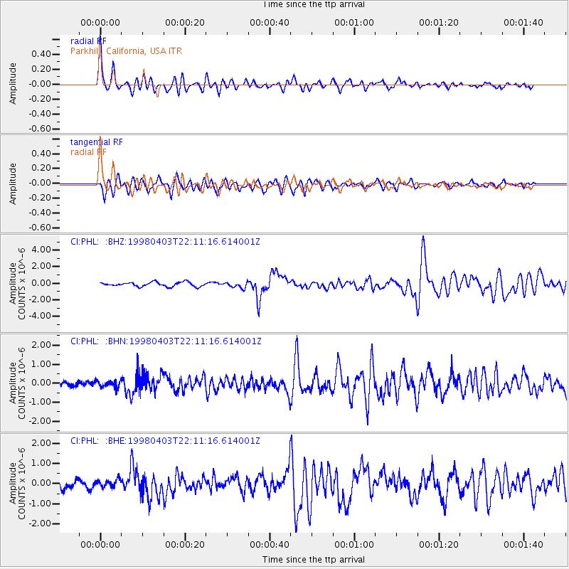
Signal To Noise
| Channel | StoN | STA | LTA |
| CI:PHL: :BHN:19980403T22:11:16.614001Z | 1.362144 | 1.708475E-7 | 1.2542543E-7 |
| CI:PHL: :BHE:19980403T22:11:16.614001Z | 0.61078244 | 1.9516614E-7 | 3.1953462E-7 |
| CI:PHL: :BHZ:19980403T22:11:16.614001Z | 1.3247801 | 3.377145E-7 | 2.549212E-7 |
| Arrivals |
| Ps | 3.0 SECOND |
| PpPs | 10 SECOND |
| PsPs/PpSs | 13 SECOND |


