You are here: Home > Network List > TA - USArray Transportable Network (new EarthScope stations) Stations List
> Station X20A Quemado, NM, USA > Earthquake Result Viewer
X20A Quemado, NM, USA - Earthquake Result Viewer
| Earthquake location: |
Svalbard Region |
| Earthquake latitude/longitude: |
77.1/18.6 |
| Earthquake time(UTC): |
2008/02/21 (052) 02:46:17 GMT |
| Earthquake Depth: |
10 km |
| Earthquake Magnitude: |
5.7 MB, 5.9 MS, 6.1 MW, 6.0 MW |
| Earthquake Catalog/Contributor: |
WHDF/NEIC |
|
| Network: |
TA USArray Transportable Network (new EarthScope stations) |
| Station: |
X20A Quemado, NM, USA |
| Lat/Lon: |
34.54 N/108.50 W |
| Elevation: |
2057 m |
|
| Distance: |
64.0 deg |
| Az: |
312.891 deg |
| Baz: |
11.52 deg |
| Ray Param: |
0.05919181 |
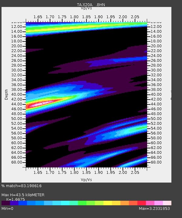
| Estimated Moho Depth: |
43.5 km |
| Estimated Crust Vp/Vs: |
1.67 |
| Assumed Crust Vp: |
6.496 km/s |
| Estimated Crust Vs: |
3.896 km/s |
| Estimated Crust Poisson's Ratio: |
0.22 |
|
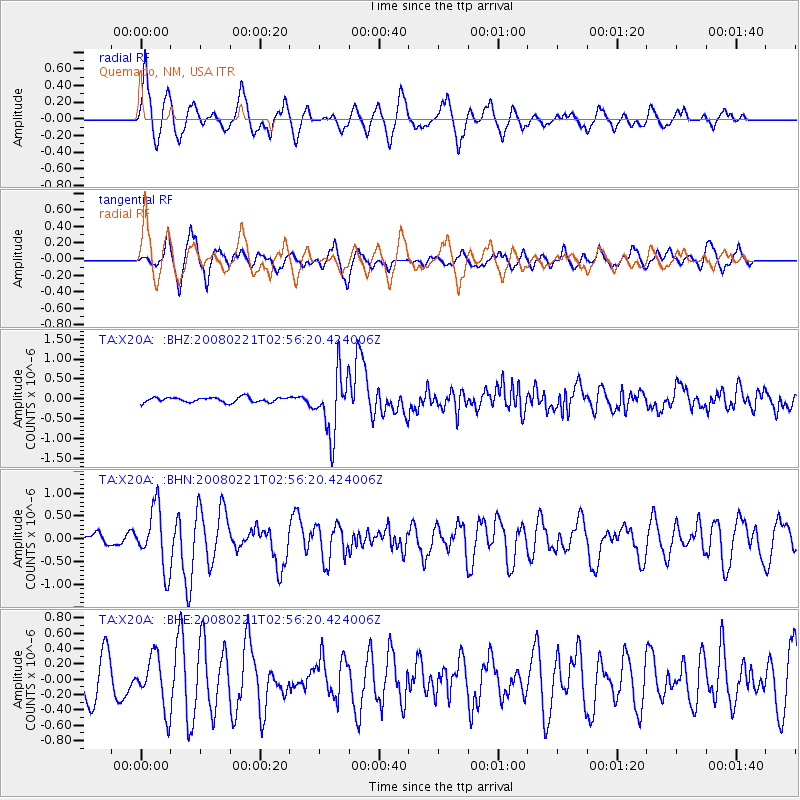
| Radial Match: |
83.198616 % |
| Radial Bump: |
385 |
| Transverse Match: |
73.18654 % |
| Transverse Bump: |
383 |
| SOD ConfigId: |
2564 |
| Insert Time: |
2010-03-06 13:42:24.771 +0000 |
| GWidth: |
2.5 |
| Max Bumps: |
400 |
| Tol: |
0.001 |
|
Signal To Noise
| Channel | StoN | STA | LTA |
| TA:X20A: :BHN:20080221T02:56:20.424006Z | 3.4725704 | 6.6057225E-7 | 1.9022573E-7 |
| TA:X20A: :BHE:20080221T02:56:20.424006Z | 1.7215918 | 3.4004904E-7 | 1.9752012E-7 |
| TA:X20A: :BHZ:20080221T02:56:20.424006Z | 12.3169985 | 7.636387E-7 | 6.199876E-8 |
| Arrivals |
| Ps | 4.7 SECOND |
| PpPs | 17 SECOND |
| PsPs/PpSs | 22 SECOND |


