You are here: Home > Network List > TA - USArray Transportable Network (new EarthScope stations) Stations List
> Station I29M Ogilvie Camp, Yukon, CA > Earthquake Result Viewer
I29M Ogilvie Camp, Yukon, CA - Earthquake Result Viewer
| Earthquake location: |
Kuril Islands |
| Earthquake latitude/longitude: |
48.5/154.8 |
| Earthquake time(UTC): |
2018/08/10 (222) 18:12:05 GMT |
| Earthquake Depth: |
16 km |
| Earthquake Magnitude: |
5.9 Mww |
| Earthquake Catalog/Contributor: |
NEIC PDE/us |
|
| Network: |
TA USArray Transportable Network (new EarthScope stations) |
| Station: |
I29M Ogilvie Camp, Yukon, CA |
| Lat/Lon: |
65.36 N/138.31 W |
| Elevation: |
602 m |
|
| Distance: |
38.1 deg |
| Az: |
38.691 deg |
| Baz: |
277.081 deg |
| Ray Param: |
0.07574607 |
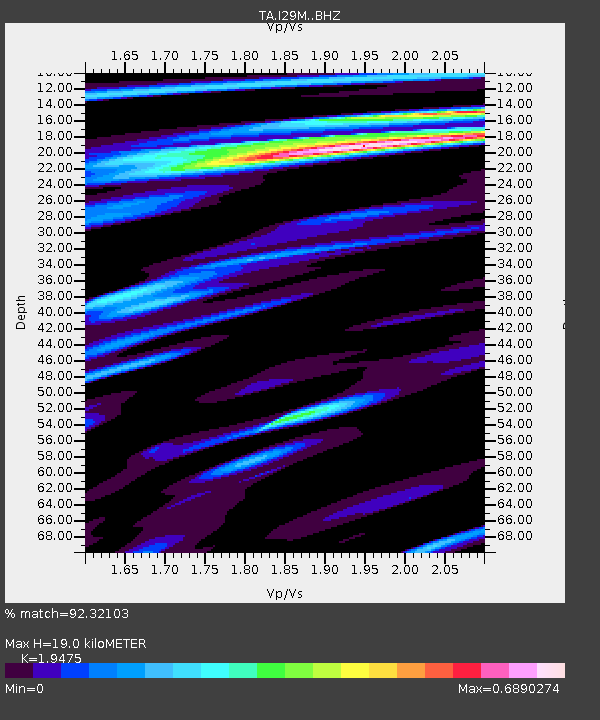
| Estimated Moho Depth: |
19.0 km |
| Estimated Crust Vp/Vs: |
1.95 |
| Assumed Crust Vp: |
6.566 km/s |
| Estimated Crust Vs: |
3.372 km/s |
| Estimated Crust Poisson's Ratio: |
0.32 |
|
| Radial Match: |
92.32103 % |
| Radial Bump: |
377 |
| Transverse Match: |
74.507866 % |
| Transverse Bump: |
400 |
| SOD ConfigId: |
13570011 |
| Insert Time: |
2019-04-30 18:40:33.105 +0000 |
| GWidth: |
2.5 |
| Max Bumps: |
400 |
| Tol: |
0.001 |
|

Signal To Noise
| Channel | StoN | STA | LTA |
| TA:I29M: :BHZ:20180810T18:18:52.45001Z | 19.026953 | 1.1409471E-6 | 5.996478E-8 |
| TA:I29M: :BHN:20180810T18:18:52.45001Z | 3.0255787 | 3.645245E-7 | 1.2048092E-7 |
| TA:I29M: :BHE:20180810T18:18:52.45001Z | 6.784953 | 7.048164E-7 | 1.0387934E-7 |
| Arrivals |
| Ps | 2.9 SECOND |
| PpPs | 8.0 SECOND |
| PsPs/PpSs | 11 SECOND |


