You are here: Home > Network List > TA - USArray Transportable Network (new EarthScope stations) Stations List
> Station J26L Joseph Creek, AK, USA > Earthquake Result Viewer
J26L Joseph Creek, AK, USA - Earthquake Result Viewer
| Earthquake location: |
Kuril Islands |
| Earthquake latitude/longitude: |
48.5/154.8 |
| Earthquake time(UTC): |
2018/08/10 (222) 18:12:05 GMT |
| Earthquake Depth: |
16 km |
| Earthquake Magnitude: |
5.9 Mww |
| Earthquake Catalog/Contributor: |
NEIC PDE/us |
|
| Network: |
TA USArray Transportable Network (new EarthScope stations) |
| Station: |
J26L Joseph Creek, AK, USA |
| Lat/Lon: |
64.50 N/143.56 W |
| Elevation: |
1144 m |
|
| Distance: |
35.9 deg |
| Az: |
40.468 deg |
| Baz: |
273.743 deg |
| Ray Param: |
0.07693477 |
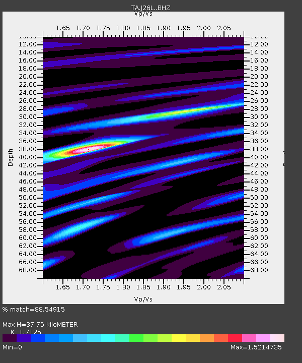
| Estimated Moho Depth: |
37.75 km |
| Estimated Crust Vp/Vs: |
1.71 |
| Assumed Crust Vp: |
6.566 km/s |
| Estimated Crust Vs: |
3.834 km/s |
| Estimated Crust Poisson's Ratio: |
0.24 |
|
| Radial Match: |
88.54915 % |
| Radial Bump: |
362 |
| Transverse Match: |
61.844944 % |
| Transverse Bump: |
400 |
| SOD ConfigId: |
13570011 |
| Insert Time: |
2019-04-30 18:40:36.883 +0000 |
| GWidth: |
2.5 |
| Max Bumps: |
400 |
| Tol: |
0.001 |
|

Signal To Noise
| Channel | StoN | STA | LTA |
| TA:J26L: :BHZ:20180810T18:18:34.20001Z | 7.302105 | 3.7770587E-7 | 5.1725614E-8 |
| TA:J26L: :BHN:20180810T18:18:34.20001Z | 1.2433388 | 5.4127064E-8 | 4.353364E-8 |
| TA:J26L: :BHE:20180810T18:18:34.20001Z | 4.3019423 | 1.8997959E-7 | 4.416135E-8 |
| Arrivals |
| Ps | 4.4 SECOND |
| PpPs | 14 SECOND |
| PsPs/PpSs | 19 SECOND |


