You are here: Home > Network List > TA - USArray Transportable Network (new EarthScope stations) Stations List
> Station X20A Quemado, NM, USA > Earthquake Result Viewer
X20A Quemado, NM, USA - Earthquake Result Viewer

| Earthquake location: |
Costa Rica |
| Earthquake latitude/longitude: |
10.2/-84.2 |
| Earthquake time(UTC): |
2009/01/08 (008) 19:21:35 GMT |
| Earthquake Depth: |
14 km |
| Earthquake Magnitude: |
5.7 MB, 6.0 MS, 6.1 MW, 6.1 MW |
| Earthquake Catalog/Contributor: |
WHDF/NEIC |
|
| Network: |
TA USArray Transportable Network (new EarthScope stations) |
| Station: |
X20A Quemado, NM, USA |
| Lat/Lon: |
34.54 N/108.50 W |
| Elevation: |
2057 m |
|
| Distance: |
32.9 deg |
| Az: |
321.283 deg |
| Baz: |
131.757 deg |
| Ray Param: |
0.07844854 |
| Estimated Moho Depth: |
37.5 km |
| Estimated Crust Vp/Vs: |
1.77 |
| Assumed Crust Vp: |
6.496 km/s |
| Estimated Crust Vs: |
3.665 km/s |
| Estimated Crust Poisson's Ratio: |
0.27 |
|
| Radial Match: |
92.20376 % |
| Radial Bump: |
229 |
| Transverse Match: |
89.20427 % |
| Transverse Bump: |
334 |
| SOD ConfigId: |
2834 |
| Insert Time: |
2010-03-06 13:42:27.965 +0000 |
| GWidth: |
2.5 |
| Max Bumps: |
400 |
| Tol: |
0.001 |
|
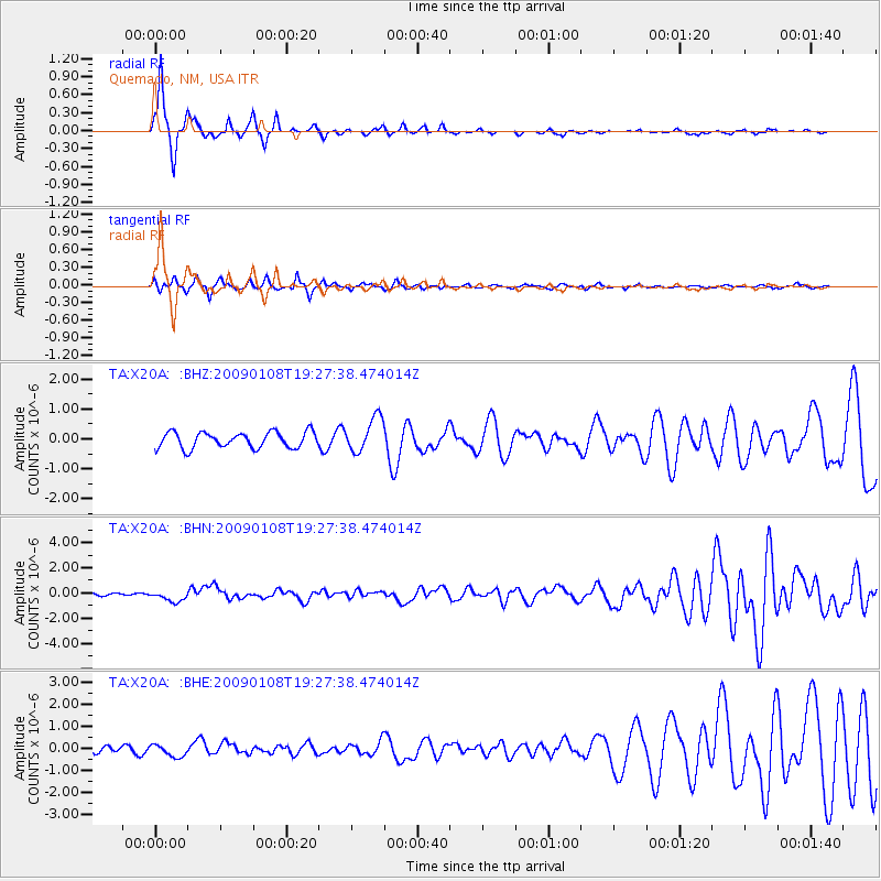
Signal To Noise
| Channel | StoN | STA | LTA |
| TA:X20A: :BHN:20090108T19:27:38.474014Z | 4.213675 | 4.3089216E-7 | 1.0226042E-7 |
| TA:X20A: :BHE:20090108T19:27:38.474014Z | 1.4151847 | 2.7099648E-7 | 1.9149194E-7 |
| TA:X20A: :BHZ:20090108T19:27:38.474014Z | 2.188944 | 5.765972E-7 | 2.634134E-7 |
| Arrivals |
| Ps | 4.8 SECOND |
| PpPs | 15 SECOND |
| PsPs/PpSs | 20 SECOND |


