You are here: Home > Network List > TA - USArray Transportable Network (new EarthScope stations) Stations List
> Station K27K Chicken, AK, USA > Earthquake Result Viewer
K27K Chicken, AK, USA - Earthquake Result Viewer
| Earthquake location: |
Kuril Islands |
| Earthquake latitude/longitude: |
48.5/154.8 |
| Earthquake time(UTC): |
2018/08/10 (222) 18:12:05 GMT |
| Earthquake Depth: |
16 km |
| Earthquake Magnitude: |
5.9 Mww |
| Earthquake Catalog/Contributor: |
NEIC PDE/us |
|
| Network: |
TA USArray Transportable Network (new EarthScope stations) |
| Station: |
K27K Chicken, AK, USA |
| Lat/Lon: |
64.03 N/142.08 W |
| Elevation: |
389 m |
|
| Distance: |
36.6 deg |
| Az: |
41.176 deg |
| Baz: |
275.652 deg |
| Ray Param: |
0.07656107 |
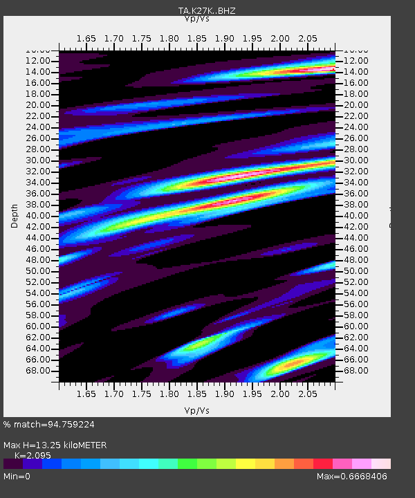
| Estimated Moho Depth: |
13.25 km |
| Estimated Crust Vp/Vs: |
2.10 |
| Assumed Crust Vp: |
6.566 km/s |
| Estimated Crust Vs: |
3.134 km/s |
| Estimated Crust Poisson's Ratio: |
0.35 |
|
| Radial Match: |
94.759224 % |
| Radial Bump: |
322 |
| Transverse Match: |
84.95785 % |
| Transverse Bump: |
400 |
| SOD ConfigId: |
13570011 |
| Insert Time: |
2019-04-30 18:40:41.218 +0000 |
| GWidth: |
2.5 |
| Max Bumps: |
400 |
| Tol: |
0.001 |
|

Signal To Noise
| Channel | StoN | STA | LTA |
| TA:K27K: :BHZ:20180810T18:18:40.024991Z | 24.977327 | 1.7414282E-6 | 6.972036E-8 |
| TA:K27K: :BHN:20180810T18:18:40.024991Z | 3.369331 | 1.5759832E-7 | 4.6774364E-8 |
| TA:K27K: :BHE:20180810T18:18:40.024991Z | 23.165918 | 1.1076817E-6 | 4.7815146E-8 |
| Arrivals |
| Ps | 2.4 SECOND |
| PpPs | 5.8 SECOND |
| PsPs/PpSs | 8.2 SECOND |


