You are here: Home > Network List > TA - USArray Transportable Network (new EarthScope stations) Stations List
> Station X20A Quemado, NM, USA > Earthquake Result Viewer
X20A Quemado, NM, USA - Earthquake Result Viewer
| Earthquake location: |
Kermadec Islands Region |
| Earthquake latitude/longitude: |
-27.4/-176.3 |
| Earthquake time(UTC): |
2009/02/18 (049) 21:53:45 GMT |
| Earthquake Depth: |
25 km |
| Earthquake Magnitude: |
6.8 MB, 7.2 MS, 6.9 MW, 6.9 MW |
| Earthquake Catalog/Contributor: |
WHDF/NEIC |
|
| Network: |
TA USArray Transportable Network (new EarthScope stations) |
| Station: |
X20A Quemado, NM, USA |
| Lat/Lon: |
34.54 N/108.50 W |
| Elevation: |
2057 m |
|
| Distance: |
89.0 deg |
| Az: |
49.871 deg |
| Baz: |
235.418 deg |
| Ray Param: |
0.04217786 |
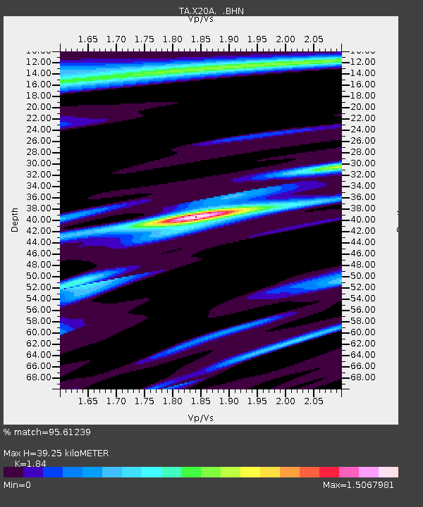
| Estimated Moho Depth: |
39.25 km |
| Estimated Crust Vp/Vs: |
1.84 |
| Assumed Crust Vp: |
6.496 km/s |
| Estimated Crust Vs: |
3.53 km/s |
| Estimated Crust Poisson's Ratio: |
0.29 |
|
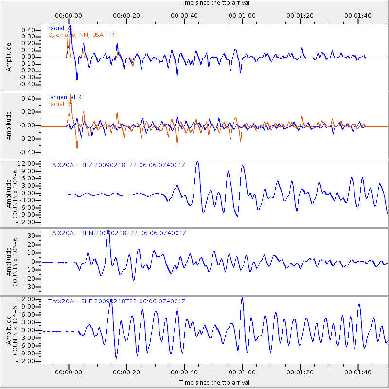
| Radial Match: |
95.61239 % |
| Radial Bump: |
355 |
| Transverse Match: |
92.576 % |
| Transverse Bump: |
363 |
| SOD ConfigId: |
2658 |
| Insert Time: |
2010-03-06 13:42:29.416 +0000 |
| GWidth: |
2.5 |
| Max Bumps: |
400 |
| Tol: |
0.001 |
|
Signal To Noise
| Channel | StoN | STA | LTA |
| TA:X20A: :BHN:20090218T22:06:06.074001Z | 25.532856 | 3.167452E-6 | 1.2405397E-7 |
| TA:X20A: :BHE:20090218T22:06:06.074001Z | 1.8929281 | 6.0606186E-7 | 3.201716E-7 |
| TA:X20A: :BHZ:20090218T22:06:06.074001Z | 2.8250003 | 1.1709218E-6 | 4.1448556E-7 |
| Arrivals |
| Ps | 5.2 SECOND |
| PpPs | 17 SECOND |
| PsPs/PpSs | 22 SECOND |


