You are here: Home > Network List > TA - USArray Transportable Network (new EarthScope stations) Stations List
> Station L20K Farewell, AK, USA > Earthquake Result Viewer
L20K Farewell, AK, USA - Earthquake Result Viewer

| Earthquake location: |
Kuril Islands |
| Earthquake latitude/longitude: |
48.5/154.8 |
| Earthquake time(UTC): |
2018/08/10 (222) 18:12:05 GMT |
| Earthquake Depth: |
16 km |
| Earthquake Magnitude: |
5.9 Mww |
| Earthquake Catalog/Contributor: |
NEIC PDE/us |
|
| Network: |
TA USArray Transportable Network (new EarthScope stations) |
| Station: |
L20K Farewell, AK, USA |
| Lat/Lon: |
62.48 N/153.88 W |
| Elevation: |
673 m |
|
| Distance: |
31.3 deg |
| Az: |
44.22 deg |
| Baz: |
267.643 deg |
| Ray Param: |
0.079087146 |
| Estimated Moho Depth: |
58.0 km |
| Estimated Crust Vp/Vs: |
1.97 |
| Assumed Crust Vp: |
6.566 km/s |
| Estimated Crust Vs: |
3.333 km/s |
| Estimated Crust Poisson's Ratio: |
0.33 |
|
| Radial Match: |
82.89737 % |
| Radial Bump: |
400 |
| Transverse Match: |
65.65588 % |
| Transverse Bump: |
400 |
| SOD ConfigId: |
13570011 |
| Insert Time: |
2019-04-30 18:40:43.479 +0000 |
| GWidth: |
2.5 |
| Max Bumps: |
400 |
| Tol: |
0.001 |
|
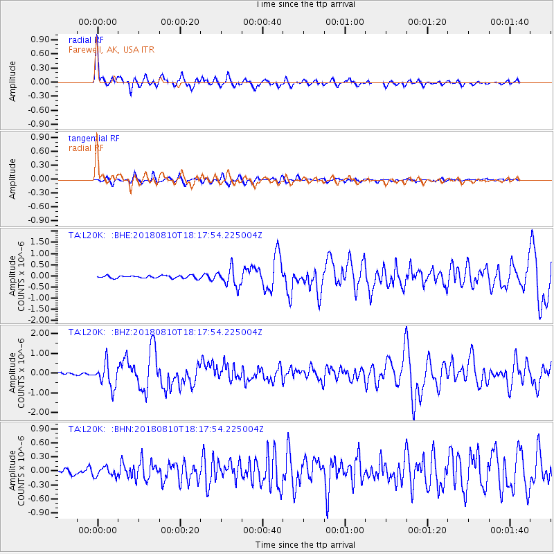
Signal To Noise
| Channel | StoN | STA | LTA |
| TA:L20K: :BHZ:20180810T18:17:54.225004Z | 6.038867 | 6.2586116E-7 | 1.0363885E-7 |
| TA:L20K: :BHN:20180810T18:17:54.225004Z | 1.6079249 | 1.0078502E-7 | 6.268018E-8 |
| TA:L20K: :BHE:20180810T18:17:54.225004Z | 6.9927974 | 4.1145648E-7 | 5.8840044E-8 |
| Arrivals |
| Ps | 9.2 SECOND |
| PpPs | 24 SECOND |
| PsPs/PpSs | 34 SECOND |


