You are here: Home > Network List > TA - USArray Transportable Network (new EarthScope stations) Stations List
> Station X20A Quemado, NM, USA > Earthquake Result Viewer
X20A Quemado, NM, USA - Earthquake Result Viewer
| Earthquake location: |
Panama-Costa Rica Border Region |
| Earthquake latitude/longitude: |
8.3/-83.0 |
| Earthquake time(UTC): |
2008/11/19 (324) 06:11:20 GMT |
| Earthquake Depth: |
32 km |
| Earthquake Magnitude: |
5.9 MB, 5.9 MS, 6.2 MW, 6.1 MW |
| Earthquake Catalog/Contributor: |
WHDF/NEIC |
|
| Network: |
TA USArray Transportable Network (new EarthScope stations) |
| Station: |
X20A Quemado, NM, USA |
| Lat/Lon: |
34.54 N/108.50 W |
| Elevation: |
2057 m |
|
| Distance: |
35.1 deg |
| Az: |
321.807 deg |
| Baz: |
132.154 deg |
| Ray Param: |
0.077328384 |
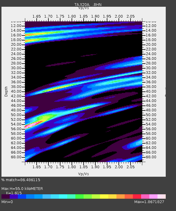
| Estimated Moho Depth: |
55.0 km |
| Estimated Crust Vp/Vs: |
1.62 |
| Assumed Crust Vp: |
6.496 km/s |
| Estimated Crust Vs: |
4.022 km/s |
| Estimated Crust Poisson's Ratio: |
0.19 |
|
| Radial Match: |
86.486115 % |
| Radial Bump: |
301 |
| Transverse Match: |
61.804283 % |
| Transverse Bump: |
400 |
| SOD ConfigId: |
2658 |
| Insert Time: |
2010-03-06 13:42:31.093 +0000 |
| GWidth: |
2.5 |
| Max Bumps: |
400 |
| Tol: |
0.001 |
|
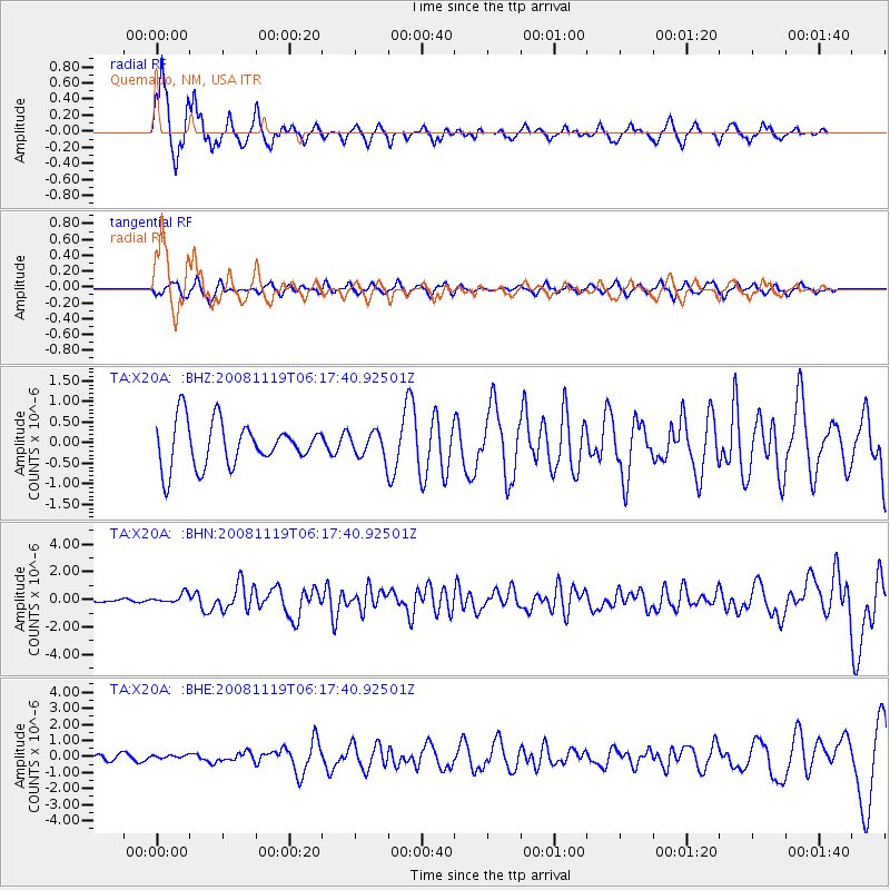
Signal To Noise
| Channel | StoN | STA | LTA |
| TA:X20A: :BHN:20081119T06:17:40.92501Z | 2.635617 | 3.4066434E-7 | 1.2925412E-7 |
| TA:X20A: :BHE:20081119T06:17:40.92501Z | 0.40907225 | 9.843554E-8 | 2.4063118E-7 |
| TA:X20A: :BHZ:20081119T06:17:40.92501Z | 0.5684442 | 3.0330278E-7 | 5.3356655E-7 |
| Arrivals |
| Ps | 5.7 SECOND |
| PpPs | 20 SECOND |
| PsPs/PpSs | 26 SECOND |


