You are here: Home > Network List > TA - USArray Transportable Network (new EarthScope stations) Stations List
> Station X20A Quemado, NM, USA > Earthquake Result Viewer
X20A Quemado, NM, USA - Earthquake Result Viewer
| Earthquake location: |
Kuril Islands |
| Earthquake latitude/longitude: |
48.3/154.2 |
| Earthquake time(UTC): |
2009/09/10 (253) 02:46:50 GMT |
| Earthquake Depth: |
36 km |
| Earthquake Magnitude: |
6.0 MB, 5.5 MS, 6.0 MW, 5.8 MW |
| Earthquake Catalog/Contributor: |
WHDF/NEIC |
|
| Network: |
TA USArray Transportable Network (new EarthScope stations) |
| Station: |
X20A Quemado, NM, USA |
| Lat/Lon: |
34.54 N/108.50 W |
| Elevation: |
2057 m |
|
| Distance: |
69.5 deg |
| Az: |
60.941 deg |
| Baz: |
315.023 deg |
| Ray Param: |
0.055546474 |
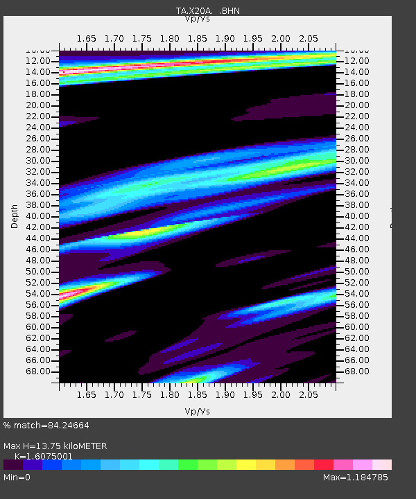
| Estimated Moho Depth: |
13.75 km |
| Estimated Crust Vp/Vs: |
1.61 |
| Assumed Crust Vp: |
6.496 km/s |
| Estimated Crust Vs: |
4.041 km/s |
| Estimated Crust Poisson's Ratio: |
0.18 |
|
| Radial Match: |
84.24664 % |
| Radial Bump: |
333 |
| Transverse Match: |
82.10447 % |
| Transverse Bump: |
387 |
| SOD ConfigId: |
2622 |
| Insert Time: |
2010-03-06 13:42:34.391 +0000 |
| GWidth: |
2.5 |
| Max Bumps: |
400 |
| Tol: |
0.001 |
|
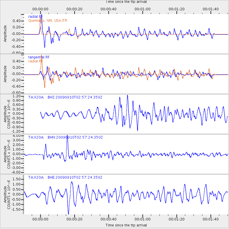
Signal To Noise
| Channel | StoN | STA | LTA |
| TA:X20A: :BHN:20090910T02:57:24.350Z | 6.920012 | 7.4144054E-7 | 1.071444E-7 |
| TA:X20A: :BHE:20090910T02:57:24.350Z | 1.9235896 | 3.6778002E-7 | 1.9119464E-7 |
| TA:X20A: :BHZ:20090910T02:57:24.350Z | 1.7186219 | 2.3367792E-7 | 1.3596821E-7 |
| Arrivals |
| Ps | 1.3 SECOND |
| PpPs | 5.3 SECOND |
| PsPs/PpSs | 6.6 SECOND |


