You are here: Home > Network List > TA - USArray Transportable Network (new EarthScope stations) Stations List
> Station X20A Quemado, NM, USA > Earthquake Result Viewer
X20A Quemado, NM, USA - Earthquake Result Viewer
| Earthquake location: |
Near Coast Of Venezuela |
| Earthquake latitude/longitude: |
10.7/-67.9 |
| Earthquake time(UTC): |
2009/09/12 (255) 20:06:24 GMT |
| Earthquake Depth: |
10 km |
| Earthquake Magnitude: |
6.3 MB, 6.4 MS, 6.3 MW, 6.3 MW |
| Earthquake Catalog/Contributor: |
WHDF/NEIC |
|
| Network: |
TA USArray Transportable Network (new EarthScope stations) |
| Station: |
X20A Quemado, NM, USA |
| Lat/Lon: |
34.54 N/108.50 W |
| Elevation: |
2057 m |
|
| Distance: |
43.9 deg |
| Az: |
309.27 deg |
| Baz: |
112.819 deg |
| Ray Param: |
0.07224151 |
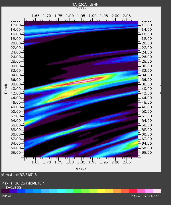
| Estimated Moho Depth: |
36.25 km |
| Estimated Crust Vp/Vs: |
1.87 |
| Assumed Crust Vp: |
6.496 km/s |
| Estimated Crust Vs: |
3.483 km/s |
| Estimated Crust Poisson's Ratio: |
0.30 |
|
| Radial Match: |
83.66916 % |
| Radial Bump: |
323 |
| Transverse Match: |
65.75737 % |
| Transverse Bump: |
329 |
| SOD ConfigId: |
2622 |
| Insert Time: |
2010-03-06 13:42:36.015 +0000 |
| GWidth: |
2.5 |
| Max Bumps: |
400 |
| Tol: |
0.001 |
|
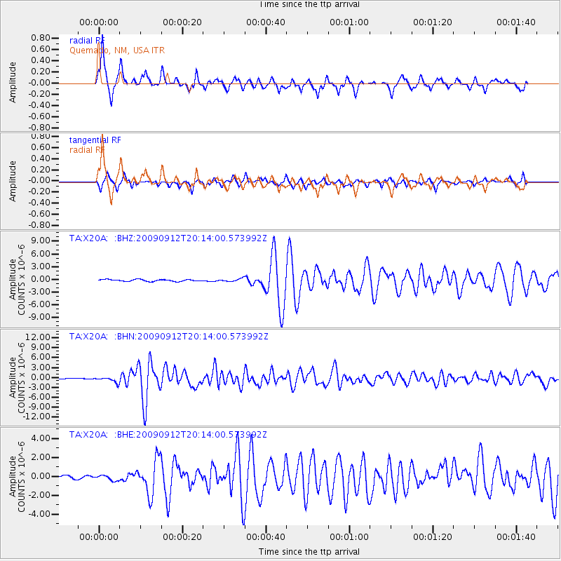
Signal To Noise
| Channel | StoN | STA | LTA |
| TA:X20A: :BHN:20090912T20:14:00.573992Z | 9.51029 | 8.650866E-7 | 9.096321E-8 |
| TA:X20A: :BHE:20090912T20:14:00.573992Z | 1.3613808 | 2.8035356E-7 | 2.0593323E-7 |
| TA:X20A: :BHZ:20090912T20:14:00.573992Z | 1.6431984 | 3.4521247E-7 | 2.1008569E-7 |
| Arrivals |
| Ps | 5.1 SECOND |
| PpPs | 15 SECOND |
| PsPs/PpSs | 20 SECOND |


