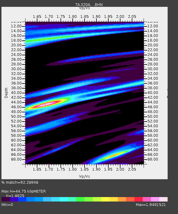
X20A Quemado, NM, USA - Earthquake Result Viewer
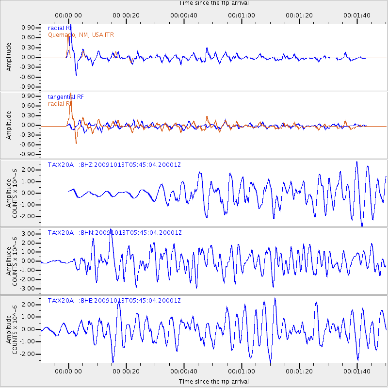
Earthquake location: Fox Islands, Aleutian Islands
Earthquake latitude/longitude: 52.8/-167.0
Earthquake time(UTC): 2009/10/13 (286) 05:37:23 GMT
Earthquake Depth: 24 km
Earthquake Magnitude: 6.0 MB, 6.1 MS, 6.5 MW, 6.5 MW
Earthquake Catalog/Contributor: WHDF/NEIC
Network: TA USArray Transportable Network (new EarthScope stations)
Station: X20A Quemado, NM, USA
Lat/Lon: 34.54 N/108.50 W
Elevation: 2057 m
Distance: 44.7 deg
Az: 89.954 deg
Baz: 312.582 deg
Ray Param: 0.071696386
Estimated Moho Depth: 44.75 km
Estimated Crust Vp/Vs: 1.68
Assumed Crust Vp: 6.496 km/s
Estimated Crust Vs: 3.861 km/s
Estimated Crust Poisson's Ratio: 0.23
Radial Match: 92.26946 %
Radial Bump: 318
Transverse Match: 84.10546 %
Transverse Bump: 400
SOD ConfigId: 2622
Insert Time: 2010-03-06 13:42:43.022 +0000
GWidth: 2.5
Max Bumps: 400
Tol: 0.001

Signal To Noise

ChannelStoNSTALTA
TA:X20A: :BHN:20091013T05:45:04.20001Z3.24894864.0864697E-71.2577823E-7
TA:X20A: :BHE:20091013T05:45:04.20001Z1.58412083.4668955E-72.1885297E-7
TA:X20A: :BHZ:20091013T05:45:04.20001Z3.18675026.0392114E-71.8951005E-7
Arrivals
Ps5.0 SECOND
PpPs17 SECOND
PsPs/PpSs22 SECOND