You are here: Home > Network List > TA - USArray Transportable Network (new EarthScope stations) Stations List
> Station Q20K Shuyak Island, AK, USA > Earthquake Result Viewer
Q20K Shuyak Island, AK, USA - Earthquake Result Viewer
| Earthquake location: |
Kuril Islands |
| Earthquake latitude/longitude: |
48.5/154.8 |
| Earthquake time(UTC): |
2018/08/10 (222) 18:12:05 GMT |
| Earthquake Depth: |
16 km |
| Earthquake Magnitude: |
5.9 Mww |
| Earthquake Catalog/Contributor: |
NEIC PDE/us |
|
| Network: |
TA USArray Transportable Network (new EarthScope stations) |
| Station: |
Q20K Shuyak Island, AK, USA |
| Lat/Lon: |
58.61 N/152.39 W |
| Elevation: |
180 m |
|
| Distance: |
32.2 deg |
| Az: |
51.562 deg |
| Baz: |
275.181 deg |
| Ray Param: |
0.0787523 |
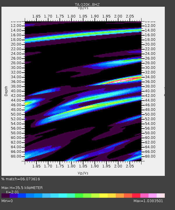
| Estimated Moho Depth: |
35.5 km |
| Estimated Crust Vp/Vs: |
2.01 |
| Assumed Crust Vp: |
5.989 km/s |
| Estimated Crust Vs: |
2.98 km/s |
| Estimated Crust Poisson's Ratio: |
0.34 |
|
| Radial Match: |
86.073616 % |
| Radial Bump: |
312 |
| Transverse Match: |
72.82444 % |
| Transverse Bump: |
400 |
| SOD ConfigId: |
13570011 |
| Insert Time: |
2019-04-30 18:41:20.540 +0000 |
| GWidth: |
2.5 |
| Max Bumps: |
400 |
| Tol: |
0.001 |
|

Signal To Noise
| Channel | StoN | STA | LTA |
| TA:Q20K: :BHZ:20180810T18:18:01.424985Z | 8.327121 | 1.146721E-6 | 1.377092E-7 |
| TA:Q20K: :BHN:20180810T18:18:01.424985Z | 2.3874147 | 2.8120036E-7 | 1.1778446E-7 |
| TA:Q20K: :BHE:20180810T18:18:01.424985Z | 6.3243318 | 7.789594E-7 | 1.2316865E-7 |
| Arrivals |
| Ps | 6.4 SECOND |
| PpPs | 17 SECOND |
| PsPs/PpSs | 23 SECOND |


