You are here: Home > Network List > TA - USArray Transportable Network (new EarthScope stations) Stations List
> Station R11B Troy Canyon, Currant, NV, USA > Earthquake Result Viewer
R11B Troy Canyon, Currant, NV, USA - Earthquake Result Viewer
| Earthquake location: |
Kuril Islands |
| Earthquake latitude/longitude: |
48.5/154.8 |
| Earthquake time(UTC): |
2018/08/10 (222) 18:12:05 GMT |
| Earthquake Depth: |
16 km |
| Earthquake Magnitude: |
5.9 Mww |
| Earthquake Catalog/Contributor: |
NEIC PDE/us |
|
| Network: |
TA USArray Transportable Network (new EarthScope stations) |
| Station: |
R11B Troy Canyon, Currant, NV, USA |
| Lat/Lon: |
38.35 N/115.59 W |
| Elevation: |
1767 m |
|
| Distance: |
62.3 deg |
| Az: |
62.601 deg |
| Baz: |
311.283 deg |
| Ray Param: |
0.06028816 |
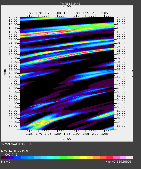
| Estimated Moho Depth: |
18.5 km |
| Estimated Crust Vp/Vs: |
1.75 |
| Assumed Crust Vp: |
6.276 km/s |
| Estimated Crust Vs: |
3.596 km/s |
| Estimated Crust Poisson's Ratio: |
0.26 |
|
| Radial Match: |
83.969826 % |
| Radial Bump: |
375 |
| Transverse Match: |
75.43069 % |
| Transverse Bump: |
400 |
| SOD ConfigId: |
13570011 |
| Insert Time: |
2019-04-30 18:41:24.439 +0000 |
| GWidth: |
2.5 |
| Max Bumps: |
400 |
| Tol: |
0.001 |
|

Signal To Noise
| Channel | StoN | STA | LTA |
| TA:R11B: :HHZ:20180810T18:21:55.409971Z | 9.446797 | 9.038921E-7 | 9.568239E-8 |
| TA:R11B: :HHN:20180810T18:21:55.409971Z | 3.7865615 | 3.2082517E-7 | 8.4727304E-8 |
| TA:R11B: :HHE:20180810T18:21:55.409971Z | 7.9088655 | 3.2300628E-7 | 4.0841037E-8 |
| Arrivals |
| Ps | 2.3 SECOND |
| PpPs | 7.8 SECOND |
| PsPs/PpSs | 10 SECOND |


