You are here: Home > Network List > TA - USArray Transportable Network (new EarthScope stations) Stations List
> Station R32K Eaglecrest, AK, USA > Earthquake Result Viewer
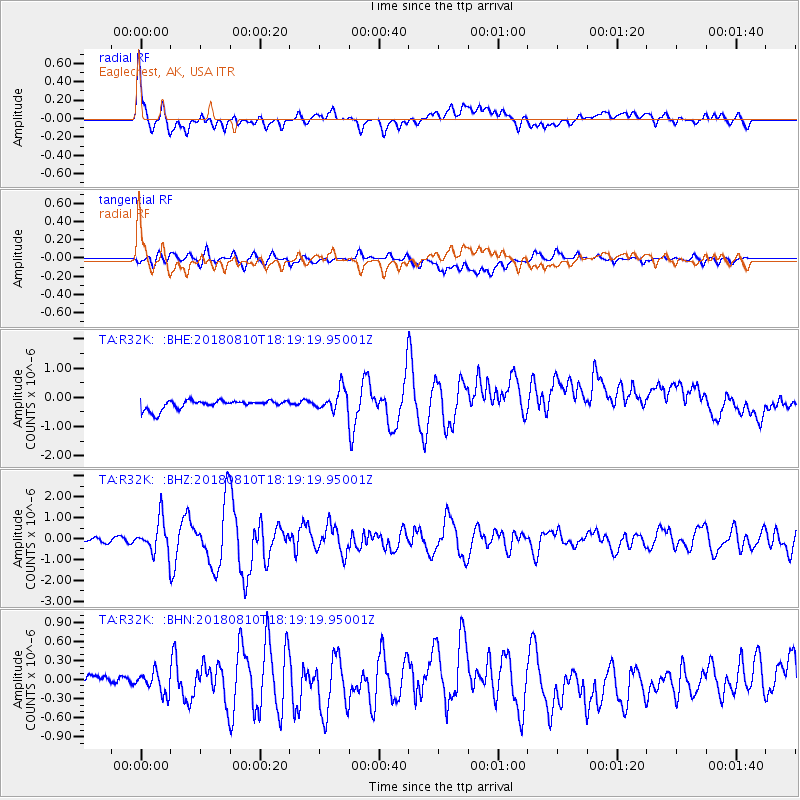
R32K Eaglecrest, AK, USA - Earthquake Result Viewer
*The percent match for this event was below the threshold and hence no stack was calculated.
| Earthquake location: |
Kuril Islands |
| Earthquake latitude/longitude: |
48.5/154.8 |
| Earthquake time(UTC): |
2018/08/10 (222) 18:12:05 GMT |
| Earthquake Depth: |
16 km |
| Earthquake Magnitude: |
5.9 Mww |
| Earthquake Catalog/Contributor: |
NEIC PDE/us |
|
| Network: |
TA USArray Transportable Network (new EarthScope stations) |
| Station: |
R32K Eaglecrest, AK, USA |
| Lat/Lon: |
58.27 N/134.52 W |
| Elevation: |
386 m |
|
| Distance: |
41.4 deg |
| Az: |
48.924 deg |
| Baz: |
288.3 deg |
| Ray Param: |
$rayparam |
*The percent match for this event was below the threshold and hence was not used in the summary stack. |
|
| Radial Match: |
75.83055 % |
| Radial Bump: |
400 |
| Transverse Match: |
72.38435 % |
| Transverse Bump: |
400 |
| SOD ConfigId: |
13570011 |
| Insert Time: |
2019-04-30 18:41:25.716 +0000 |
| GWidth: |
2.5 |
| Max Bumps: |
400 |
| Tol: |
0.001 |
|
Signal To Noise
| Channel | StoN | STA | LTA |
| TA:R32K: :BHZ:20180810T18:19:19.95001Z | 8.598404 | 7.9463274E-7 | 9.241631E-8 |
| TA:R32K: :BHN:20180810T18:19:19.95001Z | 1.145144 | 1.6564847E-7 | 1.4465297E-7 |
| TA:R32K: :BHE:20180810T18:19:19.95001Z | 2.8022232 | 4.1875134E-7 | 1.494354E-7 |
| Arrivals |
| Ps | |
| PpPs | |
| PsPs/PpSs | |


