You are here: Home > Network List > TA - USArray Transportable Network (new EarthScope stations) Stations List
> Station X20A Quemado, NM, USA > Earthquake Result Viewer
X20A Quemado, NM, USA - Earthquake Result Viewer
| Earthquake location: |
Hokkaido, Japan Region |
| Earthquake latitude/longitude: |
41.8/143.4 |
| Earthquake time(UTC): |
2009/06/05 (156) 03:30:33 GMT |
| Earthquake Depth: |
29 km |
| Earthquake Magnitude: |
6.0 MB, 6.3 MS, 6.4 MW, 6.4 MW |
| Earthquake Catalog/Contributor: |
WHDF/NEIC |
|
| Network: |
TA USArray Transportable Network (new EarthScope stations) |
| Station: |
X20A Quemado, NM, USA |
| Lat/Lon: |
34.54 N/108.50 W |
| Elevation: |
2057 m |
|
| Distance: |
79.4 deg |
| Az: |
52.979 deg |
| Baz: |
313.704 deg |
| Ray Param: |
0.048941292 |
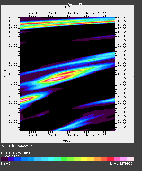
| Estimated Moho Depth: |
42.25 km |
| Estimated Crust Vp/Vs: |
1.78 |
| Assumed Crust Vp: |
6.496 km/s |
| Estimated Crust Vs: |
3.644 km/s |
| Estimated Crust Poisson's Ratio: |
0.27 |
|
| Radial Match: |
90.522606 % |
| Radial Bump: |
287 |
| Transverse Match: |
73.47639 % |
| Transverse Bump: |
400 |
| SOD ConfigId: |
2648 |
| Insert Time: |
2010-03-06 13:42:48.420 +0000 |
| GWidth: |
2.5 |
| Max Bumps: |
400 |
| Tol: |
0.001 |
|
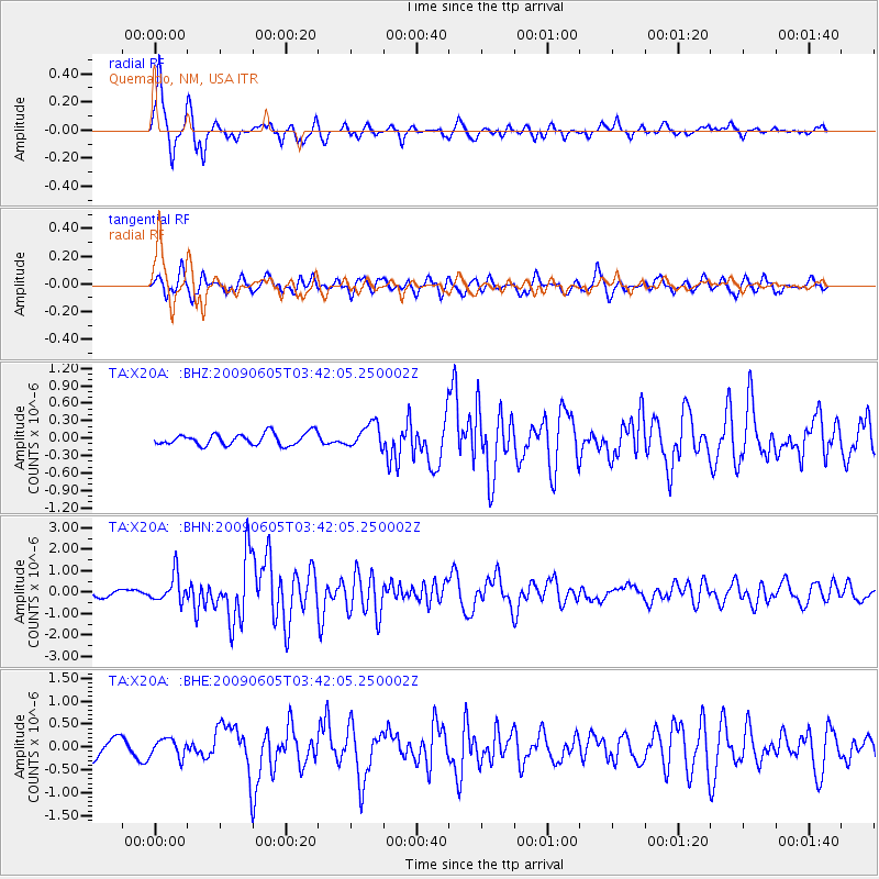
Signal To Noise
| Channel | StoN | STA | LTA |
| TA:X20A: :BHN:20090605T03:42:05.250002Z | 4.5174594 | 6.301081E-7 | 1.3948285E-7 |
| TA:X20A: :BHE:20090605T03:42:05.250002Z | 1.232228 | 1.9711143E-7 | 1.5996343E-7 |
| TA:X20A: :BHZ:20090605T03:42:05.250002Z | 2.0206187 | 2.0684666E-7 | 1.02367984E-7 |
| Arrivals |
| Ps | 5.2 SECOND |
| PpPs | 18 SECOND |
| PsPs/PpSs | 23 SECOND |


