You are here: Home > Network List > TA - USArray Transportable Network (new EarthScope stations) Stations List
> Station SUSD Miller, SD, USA > Earthquake Result Viewer
SUSD Miller, SD, USA - Earthquake Result Viewer
| Earthquake location: |
Kuril Islands |
| Earthquake latitude/longitude: |
48.5/154.8 |
| Earthquake time(UTC): |
2018/08/10 (222) 18:12:05 GMT |
| Earthquake Depth: |
16 km |
| Earthquake Magnitude: |
5.9 Mww |
| Earthquake Catalog/Contributor: |
NEIC PDE/us |
|
| Network: |
TA USArray Transportable Network (new EarthScope stations) |
| Station: |
SUSD Miller, SD, USA |
| Lat/Lon: |
44.44 N/98.96 W |
| Elevation: |
520 m |
|
| Distance: |
67.2 deg |
| Az: |
48.228 deg |
| Baz: |
316.138 deg |
| Ray Param: |
0.057089463 |
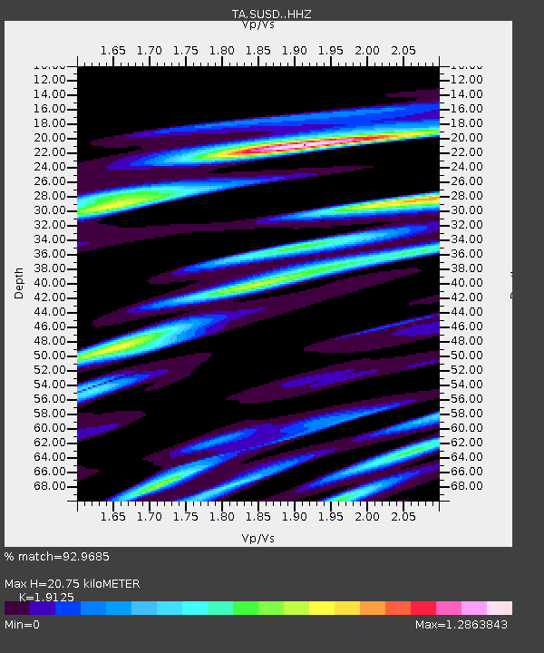
| Estimated Moho Depth: |
20.75 km |
| Estimated Crust Vp/Vs: |
1.91 |
| Assumed Crust Vp: |
6.53 km/s |
| Estimated Crust Vs: |
3.415 km/s |
| Estimated Crust Poisson's Ratio: |
0.31 |
|
| Radial Match: |
92.9685 % |
| Radial Bump: |
400 |
| Transverse Match: |
88.491936 % |
| Transverse Bump: |
400 |
| SOD ConfigId: |
13570011 |
| Insert Time: |
2019-04-30 18:41:31.395 +0000 |
| GWidth: |
2.5 |
| Max Bumps: |
400 |
| Tol: |
0.001 |
|

Signal To Noise
| Channel | StoN | STA | LTA |
| TA:SUSD: :HHZ:20180810T18:22:27.340024Z | 14.453658 | 1.1727428E-6 | 8.113813E-8 |
| TA:SUSD: :HHN:20180810T18:22:27.340024Z | 5.467461 | 7.389162E-7 | 1.3514796E-7 |
| TA:SUSD: :HHE:20180810T18:22:27.340024Z | 7.919035 | 1.3512876E-6 | 1.706379E-7 |
| Arrivals |
| Ps | 3.0 SECOND |
| PpPs | 8.9 SECOND |
| PsPs/PpSs | 12 SECOND |


