You are here: Home > Network List > TA - USArray Transportable Network (new EarthScope stations) Stations List
> Station X20A Quemado, NM, USA > Earthquake Result Viewer
X20A Quemado, NM, USA - Earthquake Result Viewer
| Earthquake location: |
Sea Of Okhotsk |
| Earthquake latitude/longitude: |
54.2/154.3 |
| Earthquake time(UTC): |
2008/11/24 (329) 09:02:58 GMT |
| Earthquake Depth: |
492 km |
| Earthquake Magnitude: |
6.5 MB, 7.3 MW, 7.3 MW |
| Earthquake Catalog/Contributor: |
WHDF/NEIC |
|
| Network: |
TA USArray Transportable Network (new EarthScope stations) |
| Station: |
X20A Quemado, NM, USA |
| Lat/Lon: |
34.54 N/108.50 W |
| Elevation: |
2057 m |
|
| Distance: |
66.7 deg |
| Az: |
63.123 deg |
| Baz: |
320.593 deg |
| Ray Param: |
0.055771 |
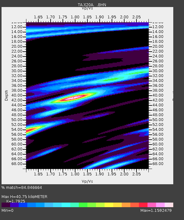
| Estimated Moho Depth: |
40.75 km |
| Estimated Crust Vp/Vs: |
1.79 |
| Assumed Crust Vp: |
6.496 km/s |
| Estimated Crust Vs: |
3.624 km/s |
| Estimated Crust Poisson's Ratio: |
0.27 |
|
| Radial Match: |
84.846664 % |
| Radial Bump: |
262 |
| Transverse Match: |
71.451065 % |
| Transverse Bump: |
336 |
| SOD ConfigId: |
2658 |
| Insert Time: |
2010-03-06 13:42:49.991 +0000 |
| GWidth: |
2.5 |
| Max Bumps: |
400 |
| Tol: |
0.001 |
|
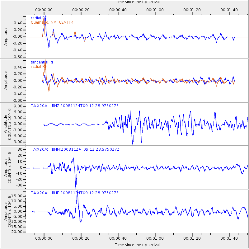
Signal To Noise
| Channel | StoN | STA | LTA |
| TA:X20A: :BHN:20081124T09:12:28.975027Z | 28.622242 | 3.8603844E-6 | 1.3487359E-7 |
| TA:X20A: :BHE:20081124T09:12:28.975027Z | 9.718151 | 1.2871751E-6 | 1.3245062E-7 |
| TA:X20A: :BHZ:20081124T09:12:28.975027Z | 2.0139077 | 6.6496335E-7 | 3.301856E-7 |
| Arrivals |
| Ps | 5.2 SECOND |
| PpPs | 17 SECOND |
| PsPs/PpSs | 22 SECOND |


