You are here: Home > Network List > TA - USArray Transportable Network (new EarthScope stations) Stations List
> Station X20A Quemado, NM, USA > Earthquake Result Viewer
X20A Quemado, NM, USA - Earthquake Result Viewer
| Earthquake location: |
Kermadec Islands Region |
| Earthquake latitude/longitude: |
-31.2/-176.9 |
| Earthquake time(UTC): |
2008/12/09 (344) 06:23:59 GMT |
| Earthquake Depth: |
18 km |
| Earthquake Magnitude: |
6.2 MB, 6.7 MS, 6.8 MW, 6.7 MW |
| Earthquake Catalog/Contributor: |
WHDF/NEIC |
|
| Network: |
TA USArray Transportable Network (new EarthScope stations) |
| Station: |
X20A Quemado, NM, USA |
| Lat/Lon: |
34.54 N/108.50 W |
| Elevation: |
2057 m |
|
| Distance: |
91.8 deg |
| Az: |
50.177 deg |
| Baz: |
232.844 deg |
| Ray Param: |
0.041553877 |
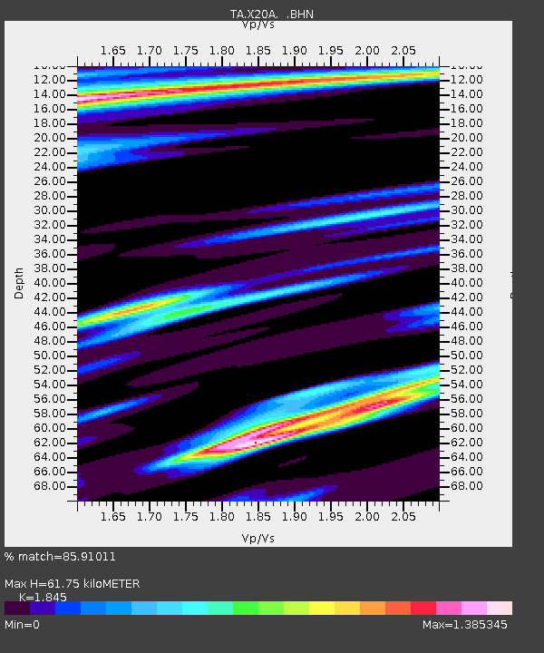
| Estimated Moho Depth: |
61.75 km |
| Estimated Crust Vp/Vs: |
1.85 |
| Assumed Crust Vp: |
6.496 km/s |
| Estimated Crust Vs: |
3.521 km/s |
| Estimated Crust Poisson's Ratio: |
0.29 |
|
| Radial Match: |
85.91011 % |
| Radial Bump: |
396 |
| Transverse Match: |
56.58499 % |
| Transverse Bump: |
339 |
| SOD ConfigId: |
2658 |
| Insert Time: |
2010-03-06 13:42:56.368 +0000 |
| GWidth: |
2.5 |
| Max Bumps: |
400 |
| Tol: |
0.001 |
|
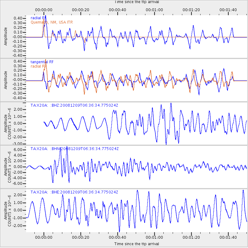
Signal To Noise
| Channel | StoN | STA | LTA |
| TA:X20A: :BHN:20081209T06:36:34.775024Z | 5.4844313 | 1.2859779E-6 | 2.3447788E-7 |
| TA:X20A: :BHE:20081209T06:36:34.775024Z | 2.3103933 | 1.1111316E-6 | 4.809275E-7 |
| TA:X20A: :BHZ:20081209T06:36:34.775024Z | 1.0067254 | 5.8730615E-7 | 5.8338264E-7 |
| Arrivals |
| Ps | 8.2 SECOND |
| PpPs | 27 SECOND |
| PsPs/PpSs | 35 SECOND |


