You are here: Home > Network List > TJ - Tajikistan National Seismic Network Stations List
> Station MANEM Manem, Tajikistan > Earthquake Result Viewer
MANEM Manem, Tajikistan - Earthquake Result Viewer
| Earthquake location: |
Kuril Islands |
| Earthquake latitude/longitude: |
48.5/154.8 |
| Earthquake time(UTC): |
2018/08/10 (222) 18:12:05 GMT |
| Earthquake Depth: |
16 km |
| Earthquake Magnitude: |
5.9 Mww |
| Earthquake Catalog/Contributor: |
NEIC PDE/us |
|
| Network: |
TJ Tajikistan National Seismic Network |
| Station: |
MANEM Manem, Tajikistan |
| Lat/Lon: |
37.53 N/71.66 E |
| Elevation: |
2312 m |
|
| Distance: |
58.9 deg |
| Az: |
292.847 deg |
| Baz: |
50.483 deg |
| Ray Param: |
0.06251565 |
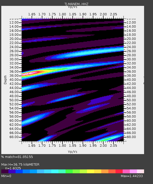
| Estimated Moho Depth: |
36.75 km |
| Estimated Crust Vp/Vs: |
1.63 |
| Assumed Crust Vp: |
6.306 km/s |
| Estimated Crust Vs: |
3.863 km/s |
| Estimated Crust Poisson's Ratio: |
0.20 |
|
| Radial Match: |
81.85155 % |
| Radial Bump: |
400 |
| Transverse Match: |
71.281845 % |
| Transverse Bump: |
400 |
| SOD ConfigId: |
13570011 |
| Insert Time: |
2019-04-30 18:41:49.479 +0000 |
| GWidth: |
2.5 |
| Max Bumps: |
400 |
| Tol: |
0.001 |
|

Signal To Noise
| Channel | StoN | STA | LTA |
| TJ:MANEM: :HHZ:20180810T18:21:33.499998Z | 11.425954 | 1.3341393E-6 | 1.16763935E-7 |
| TJ:MANEM: :HHN:20180810T18:21:33.499998Z | 4.001745 | 3.8832678E-7 | 9.7039354E-8 |
| TJ:MANEM: :HHE:20180810T18:21:33.499998Z | 3.2246964 | 3.775664E-7 | 1.1708587E-7 |
| Arrivals |
| Ps | 3.9 SECOND |
| PpPs | 15 SECOND |
| PsPs/PpSs | 18 SECOND |


