You are here: Home > Network List > CI - Caltech Regional Seismic Network Stations List
> Station PHL Parkhill, California, USA > Earthquake Result Viewer
PHL Parkhill, California, USA - Earthquake Result Viewer
| Earthquake location: |
Near Coast Of Ecuador |
| Earthquake latitude/longitude: |
-0.6/-80.4 |
| Earthquake time(UTC): |
1998/08/04 (216) 18:59:20 GMT |
| Earthquake Depth: |
33 km |
| Earthquake Magnitude: |
6.2 MB, 7.1 MS, 7.1 UNKNOWN, 7.0 ME |
| Earthquake Catalog/Contributor: |
WHDF/NEIC |
|
| Network: |
CI Caltech Regional Seismic Network |
| Station: |
PHL Parkhill, California, USA |
| Lat/Lon: |
35.41 N/120.55 W |
| Elevation: |
351 m |
|
| Distance: |
51.8 deg |
| Az: |
317.912 deg |
| Baz: |
124.866 deg |
| Ray Param: |
0.067112096 |
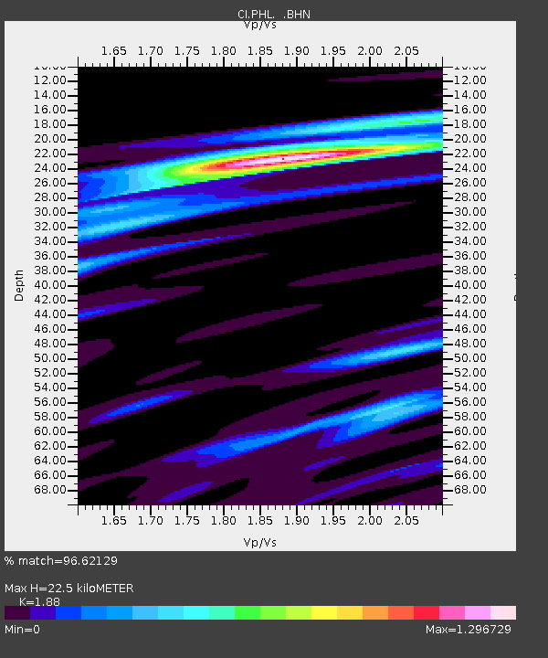
| Estimated Moho Depth: |
22.5 km |
| Estimated Crust Vp/Vs: |
1.88 |
| Assumed Crust Vp: |
6.183 km/s |
| Estimated Crust Vs: |
3.289 km/s |
| Estimated Crust Poisson's Ratio: |
0.30 |
|
| Radial Match: |
96.62129 % |
| Radial Bump: |
351 |
| Transverse Match: |
84.60215 % |
| Transverse Bump: |
400 |
| SOD ConfigId: |
3787 |
| Insert Time: |
2010-02-26 02:10:58.995 +0000 |
| GWidth: |
2.5 |
| Max Bumps: |
400 |
| Tol: |
0.001 |
|

Signal To Noise
| Channel | StoN | STA | LTA |
| CI:PHL: :BHN:19980804T19:07:54.115015Z | 0.8894438 | 3.6148495E-7 | 4.0641683E-7 |
| CI:PHL: :BHE:19980804T19:07:54.115015Z | 1.2796488 | 6.648905E-7 | 5.195883E-7 |
| CI:PHL: :BHZ:19980804T19:07:54.115015Z | 0.8337587 | 2.1993353E-7 | 2.6378558E-7 |
| Arrivals |
| Ps | 3.4 SECOND |
| PpPs | 10.0 SECOND |
| PsPs/PpSs | 13 SECOND |


