You are here: Home > Network List > UM - University of Montana - Missoula Stations List
> Station LGMT Long Gulch > Earthquake Result Viewer
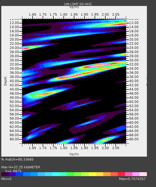
LGMT Long Gulch - Earthquake Result Viewer
| Earthquake location: |
Kuril Islands |
| Earthquake latitude/longitude: |
48.5/154.8 |
| Earthquake time(UTC): |
2018/08/10 (222) 18:12:05 GMT |
| Earthquake Depth: |
16 km |
| Earthquake Magnitude: |
5.9 Mww |
| Earthquake Catalog/Contributor: |
NEIC PDE/us |
|
| Network: |
UM University of Montana - Missoula |
| Station: |
LGMT Long Gulch |
| Lat/Lon: |
46.88 N/112.61 W |
| Elevation: |
1784 m |
|
| Distance: |
58.5 deg |
| Az: |
53.466 deg |
| Baz: |
308.78 deg |
| Ray Param: |
0.06277874 |
| Estimated Moho Depth: |
32.25 km |
| Estimated Crust Vp/Vs: |
1.97 |
| Assumed Crust Vp: |
6.353 km/s |
| Estimated Crust Vs: |
3.229 km/s |
| Estimated Crust Poisson's Ratio: |
0.33 |
|
| Radial Match: |
88.33665 % |
| Radial Bump: |
400 |
| Transverse Match: |
80.291245 % |
| Transverse Bump: |
400 |
| SOD ConfigId: |
13570011 |
| Insert Time: |
2019-04-30 18:42:05.210 +0000 |
| GWidth: |
2.5 |
| Max Bumps: |
400 |
| Tol: |
0.001 |
|

Signal To Noise
| Channel | StoN | STA | LTA |
| UM:LGMT:00:HHZ:20180810T18:21:29.510007Z | 25.3871 | 1.1291169E-6 | 4.4476007E-8 |
| UM:LGMT:00:HHN:20180810T18:21:29.510007Z | 7.1131 | 5.3882593E-7 | 7.57512E-8 |
| UM:LGMT:00:HHE:20180810T18:21:29.510007Z | 5.2090774 | 4.6405933E-7 | 8.908666E-8 |
| Arrivals |
| Ps | 5.1 SECOND |
| PpPs | 14 SECOND |
| PsPs/PpSs | 20 SECOND |


