You are here: Home > Network List > UO - University of Oregon Regional Network Stations List
> Station JESE Wamic, OR, USA > Earthquake Result Viewer
JESE Wamic, OR, USA - Earthquake Result Viewer
| Earthquake location: |
Kuril Islands |
| Earthquake latitude/longitude: |
48.5/154.8 |
| Earthquake time(UTC): |
2018/08/10 (222) 18:12:05 GMT |
| Earthquake Depth: |
16 km |
| Earthquake Magnitude: |
5.9 Mww |
| Earthquake Catalog/Contributor: |
NEIC PDE/us |
|
| Network: |
UO University of Oregon Regional Network |
| Station: |
JESE Wamic, OR, USA |
| Lat/Lon: |
45.24 N/121.32 W |
| Elevation: |
592 m |
|
| Distance: |
54.7 deg |
| Az: |
59.425 deg |
| Baz: |
305.805 deg |
| Ray Param: |
0.06528236 |
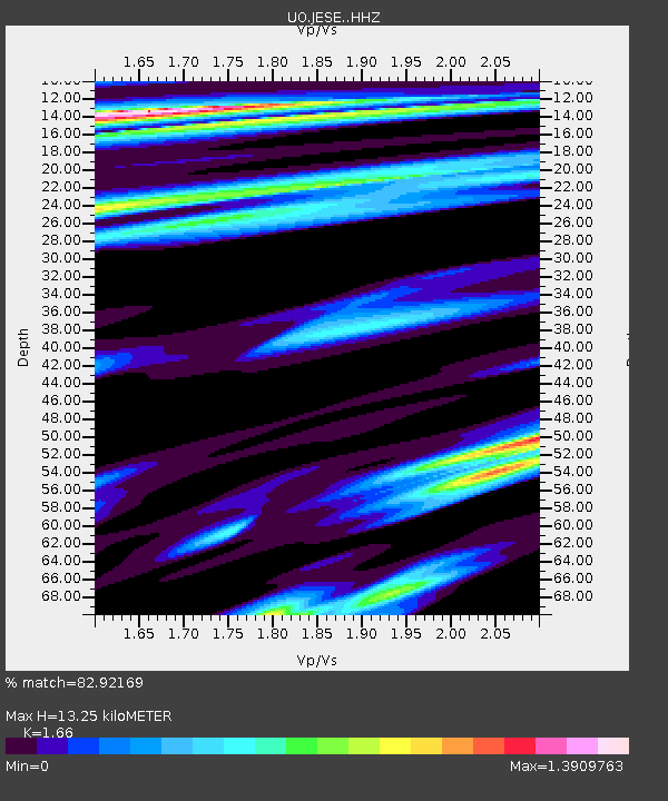
| Estimated Moho Depth: |
13.25 km |
| Estimated Crust Vp/Vs: |
1.66 |
| Assumed Crust Vp: |
6.597 km/s |
| Estimated Crust Vs: |
3.974 km/s |
| Estimated Crust Poisson's Ratio: |
0.22 |
|
| Radial Match: |
82.92169 % |
| Radial Bump: |
400 |
| Transverse Match: |
69.472145 % |
| Transverse Bump: |
400 |
| SOD ConfigId: |
13570011 |
| Insert Time: |
2019-04-30 18:42:10.725 +0000 |
| GWidth: |
2.5 |
| Max Bumps: |
400 |
| Tol: |
0.001 |
|

Signal To Noise
| Channel | StoN | STA | LTA |
| UO:JESE: :HHZ:20180810T18:21:02.228025Z | 13.843319 | 1.8592688E-6 | 1.3430802E-7 |
| UO:JESE: :HHN:20180810T18:21:02.228025Z | 2.4588704 | 2.4150964E-7 | 9.821976E-8 |
| UO:JESE: :HHE:20180810T18:21:02.228025Z | 2.3221595 | 3.3514388E-7 | 1.4432423E-7 |
| Arrivals |
| Ps | 1.4 SECOND |
| PpPs | 5.0 SECOND |
| PsPs/PpSs | 6.4 SECOND |


