You are here: Home > Network List > TA - USArray Transportable Network (new EarthScope stations) Stations List
> Station X20A Quemado, NM, USA > Earthquake Result Viewer
X20A Quemado, NM, USA - Earthquake Result Viewer
| Earthquake location: |
Panama |
| Earthquake latitude/longitude: |
9.6/-79.0 |
| Earthquake time(UTC): |
2009/07/04 (185) 06:49:35 GMT |
| Earthquake Depth: |
38 km |
| Earthquake Magnitude: |
6.0 MB, 5.5 MS, 6.0 MW, 6.0 MW |
| Earthquake Catalog/Contributor: |
WHDF/NEIC |
|
| Network: |
TA USArray Transportable Network (new EarthScope stations) |
| Station: |
X20A Quemado, NM, USA |
| Lat/Lon: |
34.54 N/108.50 W |
| Elevation: |
2057 m |
|
| Distance: |
36.7 deg |
| Az: |
317.094 deg |
| Baz: |
125.575 deg |
| Ray Param: |
0.076458044 |
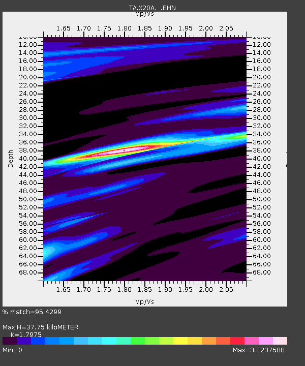
| Estimated Moho Depth: |
37.75 km |
| Estimated Crust Vp/Vs: |
1.80 |
| Assumed Crust Vp: |
6.496 km/s |
| Estimated Crust Vs: |
3.614 km/s |
| Estimated Crust Poisson's Ratio: |
0.28 |
|
| Radial Match: |
95.4299 % |
| Radial Bump: |
305 |
| Transverse Match: |
76.5768 % |
| Transverse Bump: |
399 |
| SOD ConfigId: |
2648 |
| Insert Time: |
2010-03-06 13:43:02.710 +0000 |
| GWidth: |
2.5 |
| Max Bumps: |
400 |
| Tol: |
0.001 |
|

Signal To Noise
| Channel | StoN | STA | LTA |
| TA:X20A: :BHN:20090704T06:56:08.499014Z | 18.949625 | 1.3426663E-6 | 7.085451E-8 |
| TA:X20A: :BHE:20090704T06:56:08.499014Z | 1.4287498 | 2.0123728E-7 | 1.4084851E-7 |
| TA:X20A: :BHZ:20090704T06:56:08.499014Z | 4.002407 | 4.5188142E-7 | 1.1290241E-7 |
| Arrivals |
| Ps | 5.0 SECOND |
| PpPs | 15 SECOND |
| PsPs/PpSs | 20 SECOND |


