You are here: Home > Network List > UW - Pacific Northwest Regional Seismic Network Stations List
> Station KREP White Salmon, WA, USA > Earthquake Result Viewer
KREP White Salmon, WA, USA - Earthquake Result Viewer
| Earthquake location: |
Kuril Islands |
| Earthquake latitude/longitude: |
48.5/154.8 |
| Earthquake time(UTC): |
2018/08/10 (222) 18:12:05 GMT |
| Earthquake Depth: |
16 km |
| Earthquake Magnitude: |
5.9 Mww |
| Earthquake Catalog/Contributor: |
NEIC PDE/us |
|
| Network: |
UW Pacific Northwest Regional Seismic Network |
| Station: |
KREP White Salmon, WA, USA |
| Lat/Lon: |
45.89 N/121.46 W |
| Elevation: |
472 m |
|
| Distance: |
54.2 deg |
| Az: |
58.854 deg |
| Baz: |
305.371 deg |
| Ray Param: |
0.06556693 |
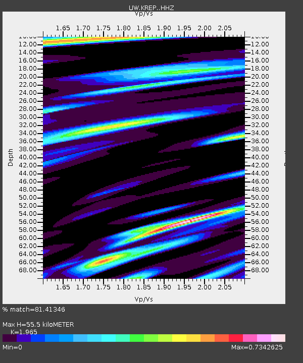
| Estimated Moho Depth: |
55.5 km |
| Estimated Crust Vp/Vs: |
1.97 |
| Assumed Crust Vp: |
6.597 km/s |
| Estimated Crust Vs: |
3.358 km/s |
| Estimated Crust Poisson's Ratio: |
0.33 |
|
| Radial Match: |
81.41346 % |
| Radial Bump: |
400 |
| Transverse Match: |
70.9043 % |
| Transverse Bump: |
400 |
| SOD ConfigId: |
13570011 |
| Insert Time: |
2019-04-30 18:42:43.352 +0000 |
| GWidth: |
2.5 |
| Max Bumps: |
400 |
| Tol: |
0.001 |
|

Signal To Noise
| Channel | StoN | STA | LTA |
| UW:KREP: :HHZ:20180810T18:20:58.91998Z | 9.561351 | 1.1176523E-6 | 1.1689272E-7 |
| UW:KREP: :HHN:20180810T18:20:58.91998Z | 2.1935925 | 2.6946438E-7 | 1.2284158E-7 |
| UW:KREP: :HHE:20180810T18:20:58.91998Z | 4.5940866 | 5.06842E-7 | 1.1032486E-7 |
| Arrivals |
| Ps | 8.5 SECOND |
| PpPs | 24 SECOND |
| PsPs/PpSs | 32 SECOND |


