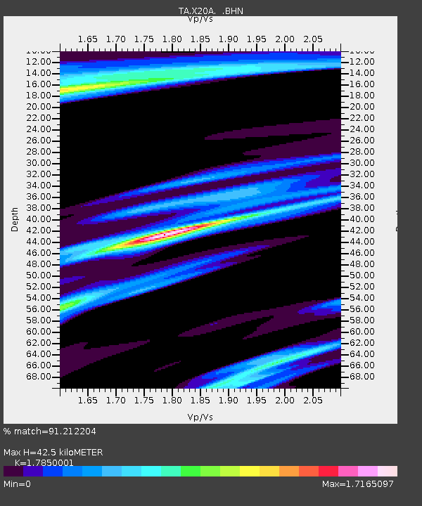
X20A Quemado, NM, USA - Earthquake Result Viewer
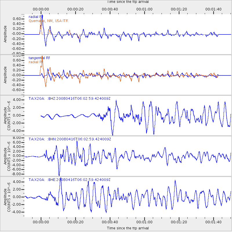
Earthquake location: Andreanof Islands, Aleutian Is.
Earthquake latitude/longitude: 51.9/-179.2
Earthquake time(UTC): 2008/04/16 (107) 05:54:19 GMT
Earthquake Depth: 13 km
Earthquake Magnitude: 6.1 MB, 6.5 MS, 6.6 MW, 6.6 MW
Earthquake Catalog/Contributor: WHDF/NEIC
Network: TA USArray Transportable Network (new EarthScope stations)
Station: X20A Quemado, NM, USA
Lat/Lon: 34.54 N/108.50 W
Elevation: 2057 m
Distance: 52.2 deg
Az: 80.135 deg
Baz: 312.281 deg
Ray Param: 0.06687641
Estimated Moho Depth: 42.5 km
Estimated Crust Vp/Vs: 1.79
Assumed Crust Vp: 6.496 km/s
Estimated Crust Vs: 3.639 km/s
Estimated Crust Poisson's Ratio: 0.27
Radial Match: 91.212204 %
Radial Bump: 356
Transverse Match: 87.80446 %
Transverse Bump: 400
SOD ConfigId: 2504
Insert Time: 2010-03-06 13:43:22.665 +0000
GWidth: 2.5
Max Bumps: 400
Tol: 0.001

Signal To Noise

ChannelStoNSTALTA
TA:X20A: :BHN:20080416T06:02:59.424009Z6.24536568.85655E-71.4180995E-7
TA:X20A: :BHE:20080416T06:02:59.424009Z1.4104024.266158E-73.0247816E-7
TA:X20A: :BHZ:20080416T06:02:59.424009Z1.33595744.040047E-73.0240838E-7
Arrivals
Ps5.4 SECOND
PpPs17 SECOND
PsPs/PpSs23 SECOND