You are here: Home > Network List > TA - USArray Transportable Network (new EarthScope stations) Stations List
> Station X20A Quemado, NM, USA > Earthquake Result Viewer
X20A Quemado, NM, USA - Earthquake Result Viewer
| Earthquake location: |
Iceland |
| Earthquake latitude/longitude: |
64.0/-21.0 |
| Earthquake time(UTC): |
2008/05/29 (150) 15:46:00 GMT |
| Earthquake Depth: |
10 km |
| Earthquake Magnitude: |
6.0 MB, 6.2 MS, 6.3 MW, 6.2 MW |
| Earthquake Catalog/Contributor: |
WHDF/NEIC |
|
| Network: |
TA USArray Transportable Network (new EarthScope stations) |
| Station: |
X20A Quemado, NM, USA |
| Lat/Lon: |
34.54 N/108.50 W |
| Elevation: |
2057 m |
|
| Distance: |
58.5 deg |
| Az: |
284.692 deg |
| Baz: |
31.091 deg |
| Ray Param: |
0.06280938 |
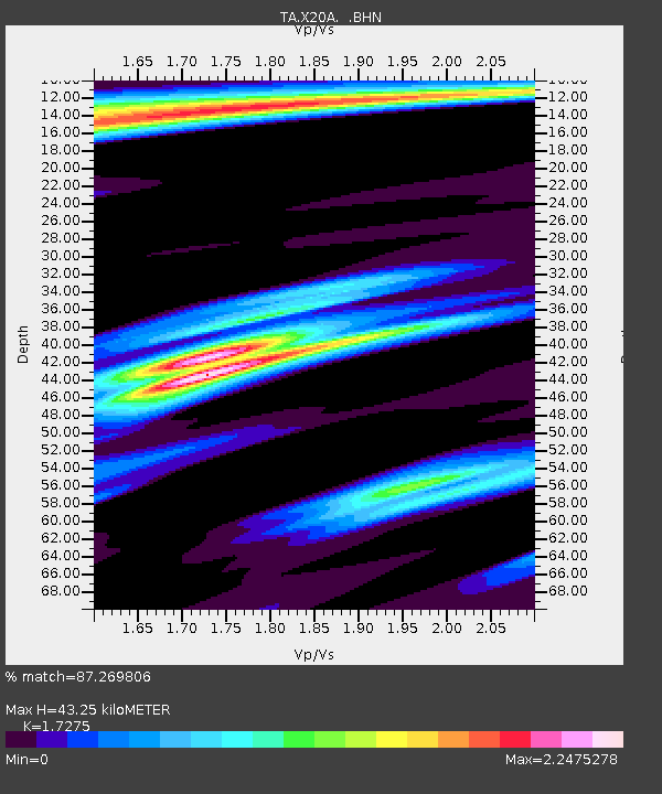
| Estimated Moho Depth: |
43.25 km |
| Estimated Crust Vp/Vs: |
1.73 |
| Assumed Crust Vp: |
6.496 km/s |
| Estimated Crust Vs: |
3.76 km/s |
| Estimated Crust Poisson's Ratio: |
0.25 |
|
| Radial Match: |
87.269806 % |
| Radial Bump: |
390 |
| Transverse Match: |
77.82792 % |
| Transverse Bump: |
352 |
| SOD ConfigId: |
2504 |
| Insert Time: |
2010-03-06 13:43:26.850 +0000 |
| GWidth: |
2.5 |
| Max Bumps: |
400 |
| Tol: |
0.001 |
|

Signal To Noise
| Channel | StoN | STA | LTA |
| TA:X20A: :BHN:20080529T15:55:25.600005Z | 9.622448 | 4.8032143E-7 | 4.9916764E-8 |
| TA:X20A: :BHE:20080529T15:55:25.600005Z | 2.2621512 | 2.6807317E-7 | 1.18503635E-7 |
| TA:X20A: :BHZ:20080529T15:55:25.600005Z | 1.6371895 | 2.2955402E-7 | 1.4021225E-7 |
| Arrivals |
| Ps | 5.1 SECOND |
| PpPs | 17 SECOND |
| PsPs/PpSs | 22 SECOND |


