You are here: Home > Network List > XO18 - AACE: Alaska Amphibious Community seismic Experimen Stations List
> Station KT08 Amook, AK > Earthquake Result Viewer
KT08 Amook, AK - Earthquake Result Viewer
| Earthquake location: |
Kuril Islands |
| Earthquake latitude/longitude: |
48.5/154.8 |
| Earthquake time(UTC): |
2018/08/10 (222) 18:12:05 GMT |
| Earthquake Depth: |
16 km |
| Earthquake Magnitude: |
5.9 Mww |
| Earthquake Catalog/Contributor: |
NEIC PDE/us |
|
| Network: |
XO AACE: Alaska Amphibious Community seismic Experimen |
| Station: |
KT08 Amook, AK |
| Lat/Lon: |
57.44 N/153.81 W |
| Elevation: |
41 m |
|
| Distance: |
31.5 deg |
| Az: |
53.908 deg |
| Baz: |
275.971 deg |
| Ray Param: |
0.079023905 |
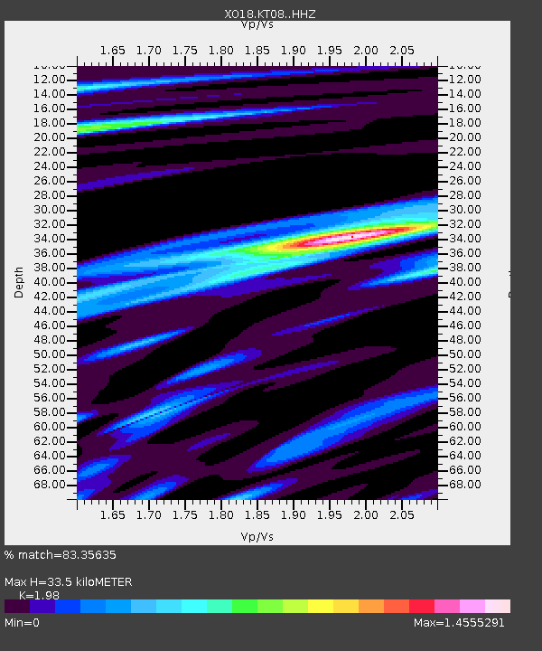
| Estimated Moho Depth: |
33.5 km |
| Estimated Crust Vp/Vs: |
1.98 |
| Assumed Crust Vp: |
6.134 km/s |
| Estimated Crust Vs: |
3.098 km/s |
| Estimated Crust Poisson's Ratio: |
0.33 |
|
| Radial Match: |
83.35635 % |
| Radial Bump: |
400 |
| Transverse Match: |
63.996864 % |
| Transverse Bump: |
400 |
| SOD ConfigId: |
13570011 |
| Insert Time: |
2019-04-30 18:43:36.595 +0000 |
| GWidth: |
2.5 |
| Max Bumps: |
400 |
| Tol: |
0.001 |
|

Signal To Noise
| Channel | StoN | STA | LTA |
| XO:KT08: :HHZ:20180810T18:17:55.799985Z | 10.641892 | 1.0255051E-6 | 9.636492E-8 |
| XO:KT08: :HHN:20180810T18:17:55.799985Z | 2.8987243 | 2.3624206E-7 | 8.149863E-8 |
| XO:KT08: :HHE:20180810T18:17:55.799985Z | 5.4012604 | 5.0952735E-7 | 9.433491E-8 |
| Arrivals |
| Ps | 5.7 SECOND |
| PpPs | 15 SECOND |
| PsPs/PpSs | 21 SECOND |


