You are here: Home > Network List > TA - USArray Transportable Network (new EarthScope stations) Stations List
> Station X20A Quemado, NM, USA > Earthquake Result Viewer
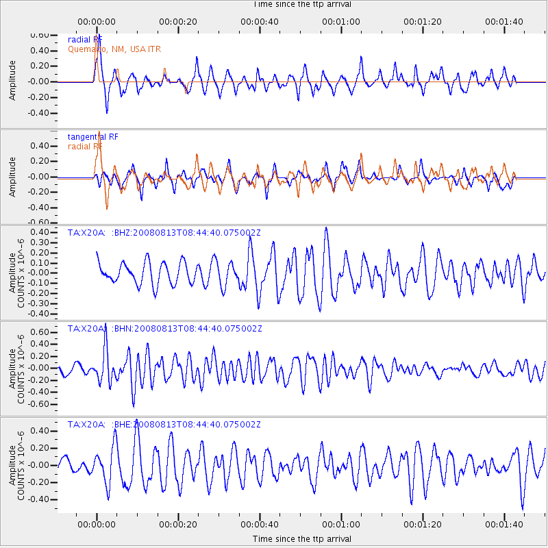
X20A Quemado, NM, USA - Earthquake Result Viewer
*The percent match for this event was below the threshold and hence no stack was calculated.
| Earthquake location: |
North Of Severnaya Zemlya |
| Earthquake latitude/longitude: |
83.6/115.2 |
| Earthquake time(UTC): |
2008/08/13 (226) 08:35:02 GMT |
| Earthquake Depth: |
10 km |
| Earthquake Magnitude: |
5.5 MB, 4.7 MS, 5.4 MW, 5.4 MW |
| Earthquake Catalog/Contributor: |
WHDF/NEIC |
|
| Network: |
TA USArray Transportable Network (new EarthScope stations) |
| Station: |
X20A Quemado, NM, USA |
| Lat/Lon: |
34.54 N/108.50 W |
| Elevation: |
2057 m |
|
| Distance: |
60.4 deg |
| Az: |
41.043 deg |
| Baz: |
354.912 deg |
| Ray Param: |
$rayparam |
*The percent match for this event was below the threshold and hence was not used in the summary stack. |
|
| Radial Match: |
63.22246 % |
| Radial Bump: |
328 |
| Transverse Match: |
47.93129 % |
| Transverse Bump: |
272 |
| SOD ConfigId: |
2504 |
| Insert Time: |
2010-03-06 13:43:36.931 +0000 |
| GWidth: |
2.5 |
| Max Bumps: |
400 |
| Tol: |
0.001 |
|
Signal To Noise
| Channel | StoN | STA | LTA |
| TA:X20A: :BHN:20080813T08:44:40.075002Z | 4.4777746 | 2.7618267E-7 | 6.1678556E-8 |
| TA:X20A: :BHE:20080813T08:44:40.075002Z | 1.7791824 | 2.1844431E-7 | 1.2277792E-7 |
| TA:X20A: :BHZ:20080813T08:44:40.075002Z | 1.1279359 | 1.16136405E-7 | 1.0296366E-7 |
| Arrivals |
| Ps | |
| PpPs | |
| PsPs/PpSs | |


