You are here: Home > Network List > TA - USArray Transportable Network (new EarthScope stations) Stations List
> Station X20A Quemado, NM, USA > Earthquake Result Viewer
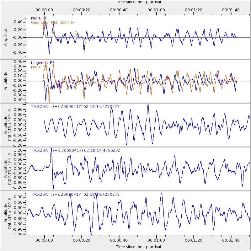
X20A Quemado, NM, USA - Earthquake Result Viewer
*The percent match for this event was below the threshold and hence no stack was calculated.
| Earthquake location: |
Near Coast Of Northern Chile |
| Earthquake latitude/longitude: |
-19.6/-70.5 |
| Earthquake time(UTC): |
2009/04/17 (107) 02:08:08 GMT |
| Earthquake Depth: |
25 km |
| Earthquake Magnitude: |
5.8 MB, 5.8 MS, 6.1 MW, 6.1 MW |
| Earthquake Catalog/Contributor: |
WHDF/NEIC |
|
| Network: |
TA USArray Transportable Network (new EarthScope stations) |
| Station: |
X20A Quemado, NM, USA |
| Lat/Lon: |
34.54 N/108.50 W |
| Elevation: |
2057 m |
|
| Distance: |
64.8 deg |
| Az: |
325.828 deg |
| Baz: |
140.093 deg |
| Ray Param: |
$rayparam |
*The percent match for this event was below the threshold and hence was not used in the summary stack. |
|
| Radial Match: |
59.38581 % |
| Radial Bump: |
386 |
| Transverse Match: |
53.06614 % |
| Transverse Bump: |
400 |
| SOD ConfigId: |
2658 |
| Insert Time: |
2010-03-06 13:43:41.978 +0000 |
| GWidth: |
2.5 |
| Max Bumps: |
400 |
| Tol: |
0.001 |
|
Signal To Noise
| Channel | StoN | STA | LTA |
| TA:X20A: :BHN:20090417T02:18:14.425027Z | 4.8588405 | 5.545523E-7 | 1.14132646E-7 |
| TA:X20A: :BHE:20090417T02:18:14.425027Z | 0.8794627 | 1.7877507E-7 | 2.032776E-7 |
| TA:X20A: :BHZ:20090417T02:18:14.425027Z | 0.88165694 | 2.9808794E-7 | 3.3809968E-7 |
| Arrivals |
| Ps | |
| PpPs | |
| PsPs/PpSs | |


