You are here: Home > Network List > 5H - Central Virginia and South Carolina seismic monitoring experiment Stations List
> Station DEBI Ferncliff, VA > Earthquake Result Viewer
DEBI Ferncliff, VA - Earthquake Result Viewer
| Earthquake location: |
Northern Alaska |
| Earthquake latitude/longitude: |
69.6/-145.3 |
| Earthquake time(UTC): |
2018/08/12 (224) 14:58:54 GMT |
| Earthquake Depth: |
2.2 km |
| Earthquake Magnitude: |
6.3 ml |
| Earthquake Catalog/Contributor: |
NEIC PDE/ak |
|
| Network: |
5H Central Virginia and South Carolina seismic monitoring experiment |
| Station: |
DEBI Ferncliff, VA |
| Lat/Lon: |
37.92 N/78.10 W |
| Elevation: |
137 m |
|
| Distance: |
47.1 deg |
| Az: |
95.636 deg |
| Baz: |
333.768 deg |
| Ray Param: |
0.070233196 |
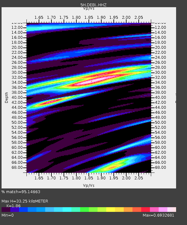
| Estimated Moho Depth: |
33.25 km |
| Estimated Crust Vp/Vs: |
1.86 |
| Assumed Crust Vp: |
6.419 km/s |
| Estimated Crust Vs: |
3.451 km/s |
| Estimated Crust Poisson's Ratio: |
0.30 |
|
| Radial Match: |
95.14663 % |
| Radial Bump: |
272 |
| Transverse Match: |
89.2417 % |
| Transverse Bump: |
400 |
| SOD ConfigId: |
13570011 |
| Insert Time: |
2019-04-30 18:46:45.331 +0000 |
| GWidth: |
2.5 |
| Max Bumps: |
400 |
| Tol: |
0.001 |
|

Signal To Noise
| Channel | StoN | STA | LTA |
| 5H:DEBI: :HHZ:20180812T15:06:56.629994Z | 22.880198 | 1.9031827E-6 | 8.318034E-8 |
| 5H:DEBI: :HHN:20180812T15:06:56.629994Z | 5.7683887 | 9.511567E-7 | 1.6489123E-7 |
| 5H:DEBI: :HHE:20180812T15:06:56.629994Z | 2.2521672 | 2.790728E-7 | 1.23913E-7 |
| Arrivals |
| Ps | 4.7 SECOND |
| PpPs | 14 SECOND |
| PsPs/PpSs | 19 SECOND |


