You are here: Home > Network List > 5H - Central Virginia and South Carolina seismic monitoring experiment Stations List
> Station HOPK Louisa, VA > Earthquake Result Viewer
HOPK Louisa, VA - Earthquake Result Viewer
| Earthquake location: |
Northern Alaska |
| Earthquake latitude/longitude: |
69.6/-145.3 |
| Earthquake time(UTC): |
2018/08/12 (224) 14:58:54 GMT |
| Earthquake Depth: |
2.2 km |
| Earthquake Magnitude: |
6.3 ml |
| Earthquake Catalog/Contributor: |
NEIC PDE/ak |
|
| Network: |
5H Central Virginia and South Carolina seismic monitoring experiment |
| Station: |
HOPK Louisa, VA |
| Lat/Lon: |
37.96 N/78.02 W |
| Elevation: |
108 m |
|
| Distance: |
47.1 deg |
| Az: |
95.534 deg |
| Baz: |
333.747 deg |
| Ray Param: |
0.070238695 |
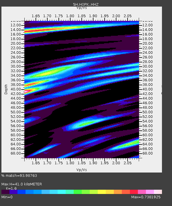
| Estimated Moho Depth: |
41.0 km |
| Estimated Crust Vp/Vs: |
1.60 |
| Assumed Crust Vp: |
6.419 km/s |
| Estimated Crust Vs: |
4.012 km/s |
| Estimated Crust Poisson's Ratio: |
0.18 |
|
| Radial Match: |
93.98763 % |
| Radial Bump: |
261 |
| Transverse Match: |
89.35633 % |
| Transverse Bump: |
400 |
| SOD ConfigId: |
13570011 |
| Insert Time: |
2019-04-30 18:46:50.593 +0000 |
| GWidth: |
2.5 |
| Max Bumps: |
400 |
| Tol: |
0.001 |
|

Signal To Noise
| Channel | StoN | STA | LTA |
| 5H:HOPK: :HHZ:20180812T15:06:56.564992Z | 19.503092 | 1.5521448E-6 | 7.958455E-8 |
| 5H:HOPK: :HHN:20180812T15:06:56.564992Z | 12.901152 | 9.61653E-7 | 7.454009E-8 |
| 5H:HOPK: :HHE:20180812T15:06:56.564992Z | 1.6363177 | 1.4007126E-7 | 8.560151E-8 |
| Arrivals |
| Ps | 4.1 SECOND |
| PpPs | 16 SECOND |
| PsPs/PpSs | 20 SECOND |


