You are here: Home > Network List > CI - Caltech Regional Seismic Network Stations List
> Station PHL Parkhill, California, USA > Earthquake Result Viewer
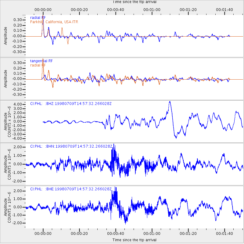
PHL Parkhill, California, USA - Earthquake Result Viewer

| Earthquake location: |
Kermadec Islands, New Zealand |
| Earthquake latitude/longitude: |
-30.5/-179.0 |
| Earthquake time(UTC): |
1998/07/09 (190) 14:45:39 GMT |
| Earthquake Depth: |
130 km |
| Earthquake Magnitude: |
6.2 MB, 6.2 MS, 6.9 UNKNOWN, 6.4 ME |
| Earthquake Catalog/Contributor: |
WHDF/NEIC |
|
| Network: |
CI Caltech Regional Seismic Network |
| Station: |
PHL Parkhill, California, USA |
| Lat/Lon: |
35.41 N/120.55 W |
| Elevation: |
351 m |
|
| Distance: |
85.5 deg |
| Az: |
44.285 deg |
| Baz: |
227.549 deg |
| Ray Param: |
0.044405807 |
| Estimated Moho Depth: |
18.0 km |
| Estimated Crust Vp/Vs: |
2.10 |
| Assumed Crust Vp: |
6.183 km/s |
| Estimated Crust Vs: |
2.948 km/s |
| Estimated Crust Poisson's Ratio: |
0.35 |
|
| Radial Match: |
91.30972 % |
| Radial Bump: |
352 |
| Transverse Match: |
78.74497 % |
| Transverse Bump: |
400 |
| SOD ConfigId: |
3787 |
| Insert Time: |
2010-02-26 02:11:03.875 +0000 |
| GWidth: |
2.5 |
| Max Bumps: |
400 |
| Tol: |
0.001 |
|
Signal To Noise
| Channel | StoN | STA | LTA |
| CI:PHL: :BHN:19980709T14:57:32.266028Z | 1.4204361 | 2.2859459E-7 | 1.6093267E-7 |
| CI:PHL: :BHE:19980709T14:57:32.266028Z | 1.9206934 | 2.884839E-7 | 1.5019779E-7 |
| CI:PHL: :BHZ:19980709T14:57:32.266028Z | 3.0893857 | 5.2642247E-7 | 1.7039714E-7 |
| Arrivals |
| Ps | 3.3 SECOND |
| PpPs | 8.9 SECOND |
| PsPs/PpSs | 12 SECOND |


