You are here: Home > Network List > TA - USArray Transportable Network (new EarthScope stations) Stations List
> Station X20A Quemado, NM, USA > Earthquake Result Viewer
X20A Quemado, NM, USA - Earthquake Result Viewer
*The percent match for this event was below the threshold and hence no stack was calculated.
| Earthquake location: |
Easter Island Region |
| Earthquake latitude/longitude: |
-28.9/-112.3 |
| Earthquake time(UTC): |
2008/05/31 (152) 23:16:04 GMT |
| Earthquake Depth: |
10 km |
| Earthquake Magnitude: |
5.5 MS, 5.4 MB, 5.8 MW, 5.8 MW |
| Earthquake Catalog/Contributor: |
WHDF/NEIC |
|
| Network: |
TA USArray Transportable Network (new EarthScope stations) |
| Station: |
X20A Quemado, NM, USA |
| Lat/Lon: |
34.54 N/108.50 W |
| Elevation: |
2057 m |
|
| Distance: |
63.2 deg |
| Az: |
3.476 deg |
| Baz: |
183.692 deg |
| Ray Param: |
$rayparam |
*The percent match for this event was below the threshold and hence was not used in the summary stack. |
|
| Radial Match: |
78.48352 % |
| Radial Bump: |
332 |
| Transverse Match: |
65.43627 % |
| Transverse Bump: |
400 |
| SOD ConfigId: |
2504 |
| Insert Time: |
2010-03-06 13:44:01.214 +0000 |
| GWidth: |
2.5 |
| Max Bumps: |
400 |
| Tol: |
0.001 |
|
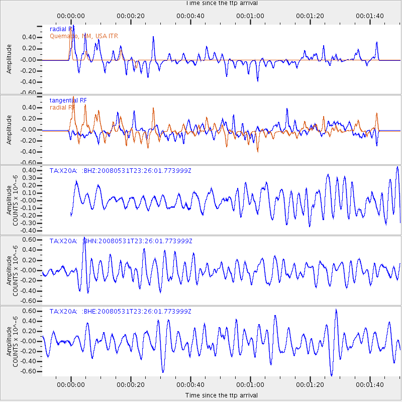
Signal To Noise
| Channel | StoN | STA | LTA |
| TA:X20A: :BHN:20080531T23:26:01.773999Z | 4.603874 | 2.6687772E-7 | 5.7968077E-8 |
| TA:X20A: :BHE:20080531T23:26:01.773999Z | 0.8290989 | 9.2191996E-8 | 1.1119542E-7 |
| TA:X20A: :BHZ:20080531T23:26:01.773999Z | 0.91135526 | 7.9844966E-8 | 8.761124E-8 |
| Arrivals |
| Ps | |
| PpPs | |
| PsPs/PpSs | |


