You are here: Home > Network List > CA - Catalan Seismic Network Stations List
> Station CSOR Soriguera > Earthquake Result Viewer
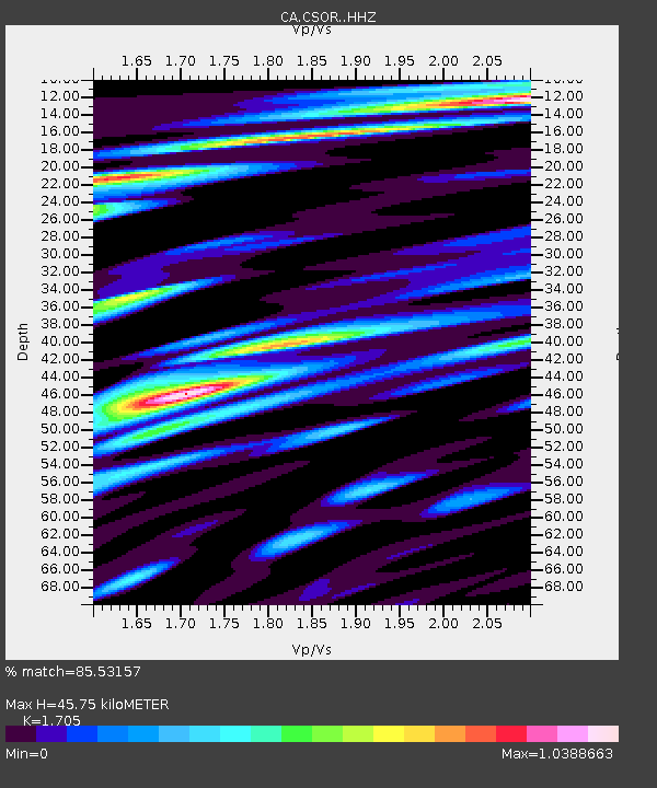
CSOR Soriguera - Earthquake Result Viewer
| Earthquake location: |
Northern Alaska |
| Earthquake latitude/longitude: |
69.6/-145.3 |
| Earthquake time(UTC): |
2018/08/12 (224) 14:58:54 GMT |
| Earthquake Depth: |
2.2 km |
| Earthquake Magnitude: |
6.3 ml |
| Earthquake Catalog/Contributor: |
NEIC PDE/ak |
|
| Network: |
CA Catalan Seismic Network |
| Station: |
CSOR Soriguera |
| Lat/Lon: |
42.37 N/1.13 E |
| Elevation: |
1227 m |
|
| Distance: |
65.7 deg |
| Az: |
26.719 deg |
| Baz: |
347.694 deg |
| Ray Param: |
0.058129426 |
| Estimated Moho Depth: |
45.75 km |
| Estimated Crust Vp/Vs: |
1.71 |
| Assumed Crust Vp: |
6.416 km/s |
| Estimated Crust Vs: |
3.763 km/s |
| Estimated Crust Poisson's Ratio: |
0.24 |
|
| Radial Match: |
85.53157 % |
| Radial Bump: |
400 |
| Transverse Match: |
80.39677 % |
| Transverse Bump: |
400 |
| SOD ConfigId: |
13570011 |
| Insert Time: |
2019-04-30 18:47:28.649 +0000 |
| GWidth: |
2.5 |
| Max Bumps: |
400 |
| Tol: |
0.001 |
|

Signal To Noise
| Channel | StoN | STA | LTA |
| CA:CSOR: :HHZ:20180812T15:09:08.850026Z | 7.9583526 | 6.5772906E-7 | 8.264639E-8 |
| CA:CSOR: :HHN:20180812T15:09:08.850026Z | 3.2719662 | 2.2019353E-7 | 6.729701E-8 |
| CA:CSOR: :HHE:20180812T15:09:08.850026Z | 1.4051256 | 8.8356245E-8 | 6.2881384E-8 |
| Arrivals |
| Ps | 5.2 SECOND |
| PpPs | 18 SECOND |
| PsPs/PpSs | 24 SECOND |


